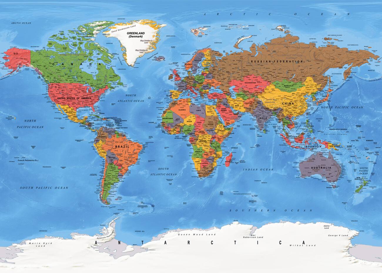
Understanding how the Earth's landmasses are divided requires looking beyond a standard schoolroom globe and examining the geological and historical forces that shaped our current planetary layout. Continents are massive continuous expanses of land that collectively cover roughly thirty percent of the Earth's surface, separated or distinguished by major oceans, tectonic boundaries, and cultural milestones.
Geographers recognize distinct models for grouping these landmasses, with the seven-continent model serving as the global standard in English-speaking nations. This framework includes Africa, Antarctica, Asia, Europe, North America, Australia, and South America. However, alternative models combine Europe and Asia into Eurasia or group North and South America into a single American landmass based on tectonic plate boundaries and continental shelves.
The Seven Continents: Area, Population, and Geography
Each continent features unique topographical signatures, climate zones, and demographic profiles that influence human settlement and ecological patterns across the globe.
Asia
Spanning approximately 44.6 million square kilometers, Asia is the largest continent on Earth, accounting for nearly thirty percent of the planet's total land area. It holds over half of the global human population, concentrated heavily in East, South, and Southeast Asia.
- Topography: Features the highest point on Earth, Mount Everest in the Himalayas, alongside vast northern taigas, arid interior deserts like the Gobi, and massive river basins such as the Yangtze and the Ganges.
- Tectonic Context: Sits primarily on the Eurasian Plate, colliding continuously with the Indian Plate to push the Himalayan mountain range higher each year.
Africa
Covering about 30.3 million square kilometers, Africa is the second-largest continent by both land area and population. Straddling the equator, it experiences diverse climatic zones ranging from hyper-arid deserts to dense equatorial rainforests.
- Topography: Dominated by the Sahara Desert in the north, the tropical Congo Basin in the center, and the East African Rift System—a massive tectonic active zone tearing the continent apart.
- Key Feature: The Nile River, historically recognized as one of the longest rivers globally, flows northward through eleven countries into the Mediterranean Sea.
North America
Covering roughly 24.7 million square kilometers, North America stretches from the frozen Arctic archipelago of Canada down through the narrow isthmus of Central America.
- Topography: Features the ancient eroded bedrock of the Canadian Shield, the expansive interior Great Plains, and the young, rugged Cordillera system running down the western coast, including the Rocky Mountains.
- Climate Range: Encapsulates arctic tundra, subarctic boreal forests, temperate grasslands, and tropical hurricane belts along the Gulf Coast.
South America
Accounting for approximately 17.8 million square kilometers, South America forms a distinct triangular shape tapering southward toward the Drake Passage.
- Topography: Defined by the Andes Mountains—the longest continental mountain range in the world—running along its western spine, and the Amazon Basin to the east.
- Key Feature: The Amazon rainforest produces roughly twenty percent of the world's oxygen and houses the Amazon River, which discharges more water than the next seven largest rivers combined.
Antarctica
Encompassing about 14.2 million square kilometers around the Earth's southern rotational axis, Antarctica is the coldest, windiest, and driest continent.
- Topography: Covered by an ice sheet that averages nearly two kilometers in thickness, locking up about seventy percent of the world's fresh water.
- Human Presence: It has no permanent residents or sovereign nations, supporting only seasonal scientific research stations operated under the Antarctic Treaty system.
Europe
Covering roughly 10.2 million square kilometers, Europe forms the western peninsula of the massive Eurasian landmass. Despite its smaller physical footprint, it holds immense historical and economic influence.
- Topography: Features an indented coastline defined by numerous peninsulas, inland seas, and mountain chains like the Alps, which were formed by the collision of the African and Eurasian plates.
- Geopolitical Complexity: Borders with Asia are traditionally drawn along the Ural Mountains, the Ural River, the Caspian Sea, and the Greater Caucasus range.
Australia
Often referred to as the smallest continent and largest island, Australia covers approximately 7.7 million square kilometers.
- Topography: Characterized by flat, ancient, and weathered terrain, with vast interior deserts (the Outback) flanked by the Great Dividing Range along the eastern coast.
- Isolation: Millions of years of geographic isolation allowed unique marsupial and monotreme species, such as kangaroos and platypuses, to evolve exclusively in this region.
Continental Boundaries and Tectonic Realities
Lines drawn on a map often mask complex geological truths. While political maps show sharp borders, geographical and geological transitions occur along specific physical features:
- Europe and Asia: Separated by convention rather than a deep ocean basin. The Ural Mountains and the Ural River mark the traditional terrestrial boundary between the two regions.
- Africa and Asia: Joined by the Sinai Peninsula, physically split by the human-made Suez Canal to facilitate maritime navigation between the Mediterranean and the Red Sea.
- North and South America: Connected by the narrow Isthmus of Panama, bisected by the Panama Canal. Geologically, they sit on separate tectonic plates moving in different directions.
Plate tectonics guarantees that these maps are temporary. The Atlantic Ocean widens by roughly two to three centimeters every year as the North American and Eurasian plates pull away from each other along the Mid-Atlantic Ridge. Meanwhile, the African Plate pushes northward into Europe, slowly closing the Mediterranean Sea over millions of years.
Climate Drivers Across the Globe
Global climate patterns don't respect political lines; they are dictated by latitude, ocean currents, and continental positioning.
[Equator] -> Solar radiation drives Hadley cells -> Tropical Rainforests (Amazon, Congo)
[Mid-Latitudes] -> Prevailing westerlies -> Temperate forests and agricultural plains
[High Latitudes] -> Polar cells -> Tundra and permanent ice sheets
Ocean currents amplify these patterns. The Gulf Stream transports warm water from the Gulf of Mexico across the Atlantic, keeping Western European winters significantly milder than corresponding latitudes in North America. Elevation further distorts standard climate expectations; high-altitude regions near the equator, such as the Andes, experience alpine tundra conditions despite tropical coordinates.
Common Misconceptions About World Maps
Cartography involves trade-offs. Representing a three-dimensional spherical globe on a two-dimensional flat piece of paper inherently distorts size, shape, or distance.
- The Mercator Distortion: The standard Mercator projection exaggerates the apparent size of landmasses far from the equator. Greenland appears roughly the same size as Africa on a standard Mercator map, even though Africa is actually fourteen times larger.
- Continents vs. Countries: People frequently confuse continental scale with national scale. Australia is both a country and a continent, whereas Asia contains nearly fifty distinct sovereign nations.
- Island Classifications: Greenland is the world's largest island, not a continent, because it sits entirely on the North American tectonic plate and lacks the landmass scale and distinct geological profile of the recognized seven continents.
Frequently Asked Questions
Is Oceania the same thing as Australia?
No. Australia is a single country and the core landmass of the continent. Oceania is a broader geographical region that includes Australia, Melanesia, Micronesia, and Polynesia.
Why is Europe considered a separate continent from Asia?
The separation is primarily historical and cultural rather than geological. Because Europe and Asia share a continuous continental plate (Eurasia), some geographers group them into a single continent, but cultural distinctions and historical divisions maintain Europe's separate status.
How many countries are in the world across these continents?
There are 195 sovereign states recognized by the United Nations, distributed unevenly across the landmasses. Asia holds the highest number of countries, followed closely by Africa.
Do tectonic plates match continental boundaries?
Not entirely. While some boundaries match—such as the North American Plate aligning roughly with North America—plates often cut across oceans and continents alike. For instance, the Pacific Plate includes oceanic crust and touches multiple continental margins without forming a continent itself.



