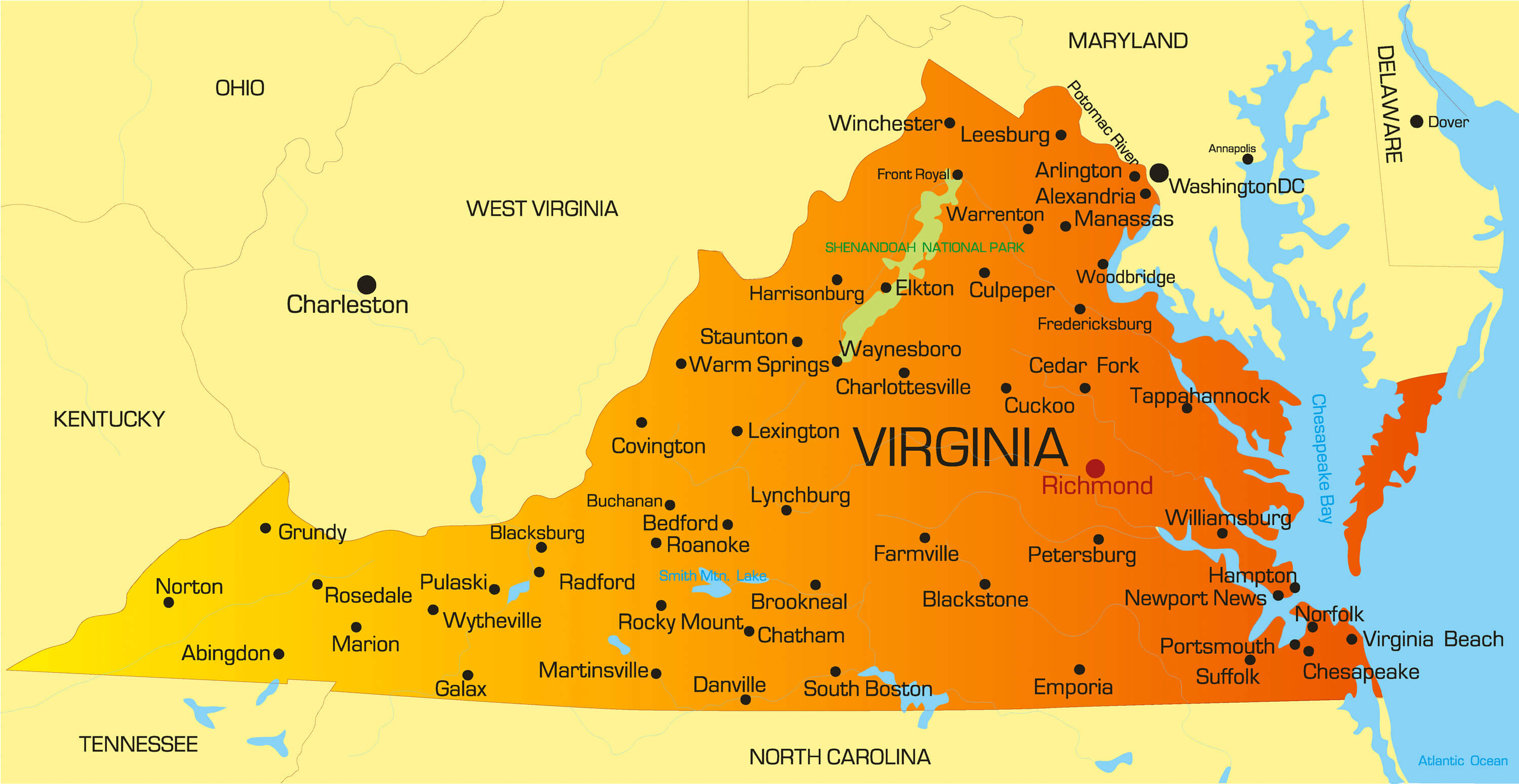
Virginia sits along the Atlantic Coast in the Mid-Atlantic and Southeastern regions of the United States. If you look at a standard map of the country, you'll find the state halfway down the eastern seaboard, acting as a historical bridge between the American North and South. Its unique shape stretches from the Atlantic Ocean westward into the Appalachian Mountains, sharing borders with five other states and the federal district of Washington, D.C.
Understanding where Virginia is located requires looking at its precise boundaries, neighboring states, and internal geographic zones. Whether you're planning a cross-country trip or studying regional American geography, pinpointing the Commonwealth on a map comes down to a few key coordinates and physical markers.
Exact Borders and Neighboring States
Virginia is bounded by a mix of natural waterways and straight-line political borders. Its surrounding neighbors shape its regional identity and economic ties:
- North and Northeast: Maryland and Washington, D.C., separated largely by the Potomac River.
- South: North Carolina and a small western border shared with Tennessee.
- West and Northwest: Kentucky and West Virginia.
- East: The Atlantic Ocean and the Chesapeake Bay.
The border with Maryland includes the Potomac River, meaning the actual water boundary often places the river's jurisdiction primarily under Maryland up to the low-water mark on the Virginia shore.
Geographic Regions Across the State
Virginia's landscape changes dramatically as you move from east to west. Geographers divide the state into distinct provinces based on elevation and soil composition.
The Tidewater and Coastal Plain
The easternmost edge of the state is defined by the Tidewater region and the Coastal Plain. This flat, low-lying area features broad tidal rivers, marshes, and the famous Chesapeake Bay. Major population hubs like Hampton Roads, Norfolk, and Virginia Beach sit right along this maritime corridor.
The Piedmont
Moving inland, the terrain rises into the Piedmont, a rolling upland region that covers a huge portion of central Virginia. Cities like Richmond (the state capital) and Charlottesville are located here. The soil transitions from sandy coastal earth to clay, and the rolling hills eventually give way to the mountains.
The Blue Ridge and Appalachian Plateau
Western Virginia is dominated by the Blue Ridge Mountains, the Shenandoah Valley, and the rugged Appalachian Plateau. Mount Rogers stands as the highest point in the state, reaching an elevation of 5,729 feet. This mountainous western panhandle pushes Virginia deep into the interior ridge-and-valley systems of the Appalachian chain.
Time Zone and Regional Classification
Virginia operates entirely within the Eastern Time Zone (UTC-5, observing Eastern Daylight Time in the summer).
Culturally and statistically, the US Census Bureau classifies Virginia as part of the South, specifically the South Atlantic division. However, due to its proximity to the nation's capital and its northern urban sprawl (such as Fairfax and Arlington counties), parts of Northern Virginia function heavily as a Mid-Atlantic economic engine.
For more detailed boundary data and official state resources, you can check the Library of Congress Maps or explore geographic definitions via the US Census Bureau.
Frequently Asked Questions
Is Virginia considered a northern or southern state?
Historically and officially, Virginia is a southern state and was even the capital of the Confederacy during the Civil War. Today, while it retains southern roots, Northern Virginia shares strong economic and cultural traits with the Mid-Atlantic and Northeastern regions.
What ocean borders Virginia?
The Atlantic Ocean borders Virginia on the far eastern coast, alongside the major indentation of the Chesapeake Bay.
What is the capital city of Virginia?
Richmond is the capital of Virginia, located in the central part of the state along the James River.
How many states border Virginia?
Five states share land or river borders with Virginia: Maryland, North Carolina, Tennessee, Kentucky, and West Virginia. Washington, D.C., also borders its northern edge across the Potomac River.



