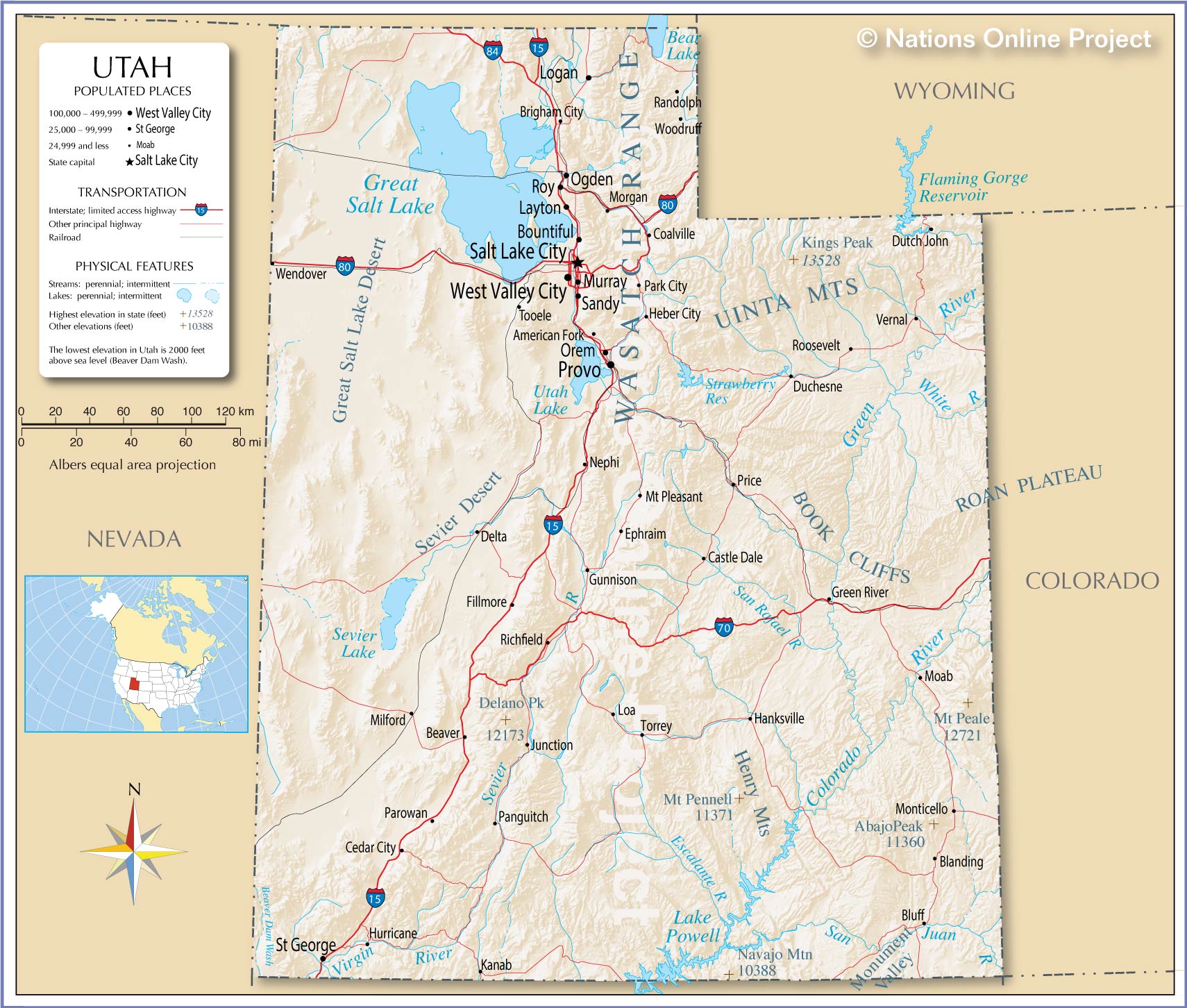
Utah occupies a unique nexus in the western United States, bounded by six neighboring states and split dramatically between high alpine peaks and arid basin deserts. If you're looking for where Utah sits on a map, its borders span from the 37th to the 42nd parallels north and from the 109th to the 114th meridians west.
Understanding Utah's exact location requires looking past basic coordinates. Its topography dictates where millions live, how snowpack feeds urban reservoirs, and why its economy has shifted from extractive mining toward high-tech corridors and global outdoor recreation hubs.
Exact Borders and Geographic Neighbors
Utah shares borders with six different states, giving it a central crossroads status in the Mountain West subregion.
- North: Idaho and a brief western slice of Wyoming.
- East: Colorado along the 109th meridian west.
- South: Arizona along the 37th parallel north, meeting the famous Four Corners monument corner with New Mexico.
- West: Nevada.
The state's total area spans roughly 84,970 square miles, making it the 13th-largest state by area in the country. Because of historical surveying quirks, its borders are almost entirely straight lines of latitude and longitude, except for a northern border segment along the Uinta Mountains and a jagged upper border carved out by the Bear Lake region.
The Three Distinct Geographic Regions
Utah isn't a monolith of red rock or snow. Geologists divide the state into three distinct physiographic provinces, each with unique terrain and climate patterns:
1. The Basin and Range Province
Occupying the western third of the state, this zone is characterized by north-south trending mountain ranges alternating with flat, arid valleys. It includes the Great Salt Lake and the vast, flat expanse of the Bonneville Salt Flats, remnants of ancient Lake Bonneville. Water here doesn't drain to any ocean; it evaporates, leaving behind thick salt deposits.
2. The Rocky Mountains (Middle Rockies)
Running diagonally through the north-central part of the state, the Wasatch Range and Uinta Mountains form a massive climatic barrier. The Wasatch Front rises steeply from the valleys, capturing Pacific storm systems and dropping up to 500 inches of dry powder snow annually. This mountain backbone supplies drinking water and hydroelectric power to the state's major population centers.
3. The Colorado Plateau
Covering the southern and eastern portions of Utah, this region features dramatic sandstone erosion, deep canyons, and towering mesas. Iconic protected areas like Zion National Park, Bryce Canyon, and Arches National Park sit within this geologic layer, carved over millions of years by the Colorado River and its tributaries.
Climate Drivers and Water Resources
Utah's location creates a severe rain shadow effect. When moist air moves inland from the Pacific Ocean, the towering peaks of the Sierra Nevada and the Wasatch Range force the air upward, cooling it and wringing out its moisture as heavy snow and rain.
By the time air descends east of the mountains, it's dry, leaving western and southern Utah with arid desert conditions. This makes water management the single most critical infrastructure challenge for the state. According to the Utah Division of Water Resources, municipal conservation and agricultural efficiency upgrades are vital as population numbers climb.
The Urban Corridor: The Wasatch Front
More than 80 percent of Utah's population lives packed into a narrow, 120-mile urban corridor known as the Wasatch Front. Nestled right against the western base of the mountains, this strip includes:
- Logan and Brigham City in the north
- Ogden
- Salt Lake City (the state capital)
- Provo and Orem in the south
Major transportation arteries like Interstate 15 run parallel to the mountains through this valley. Commuters rely heavily on the Utah Transit Authority's TRAX light rail and FrontRunner commuter rail systems to navigate the corridor, bypassing roadway congestion caused by rapid suburban growth.
Frequently Asked Questions
What time zone is Utah in?
Utah operates on Mountain Time (MT). The state observes Daylight Saving Time, shifting between Mountain Standard Time (MST, UTC-7) and Mountain Daylight Time (MDT, UTC-6). A small portion of western Utah near the Nevada border unofficially observes Pacific Time.
Is Utah part of the Pacific Northwest or the Southwest?
Neither. Utah is classified as part of the Mountain West or Intermountain West. It bridges the cultural and ecological traits of the desert Southwest and the rugged high-altitude northern Rockies.
How high is Utah above sea level?
Utah's average elevation is about 6,100 feet above sea level. Its lowest point is Beaverdam Wash at 2,190 feet in the southwest corner, while its highest point is Kings Peak in the Uinta Mountains, reaching 13,528 feet.
Why is Utah called the Beehive State?
The nickname reflects the pioneering heritage of early settlers who arrived in the Salt Lake Valley in 1847. They chose the beehive as a symbol of industriousness, cooperation, and perseverance in building a community in an arid landscape.



