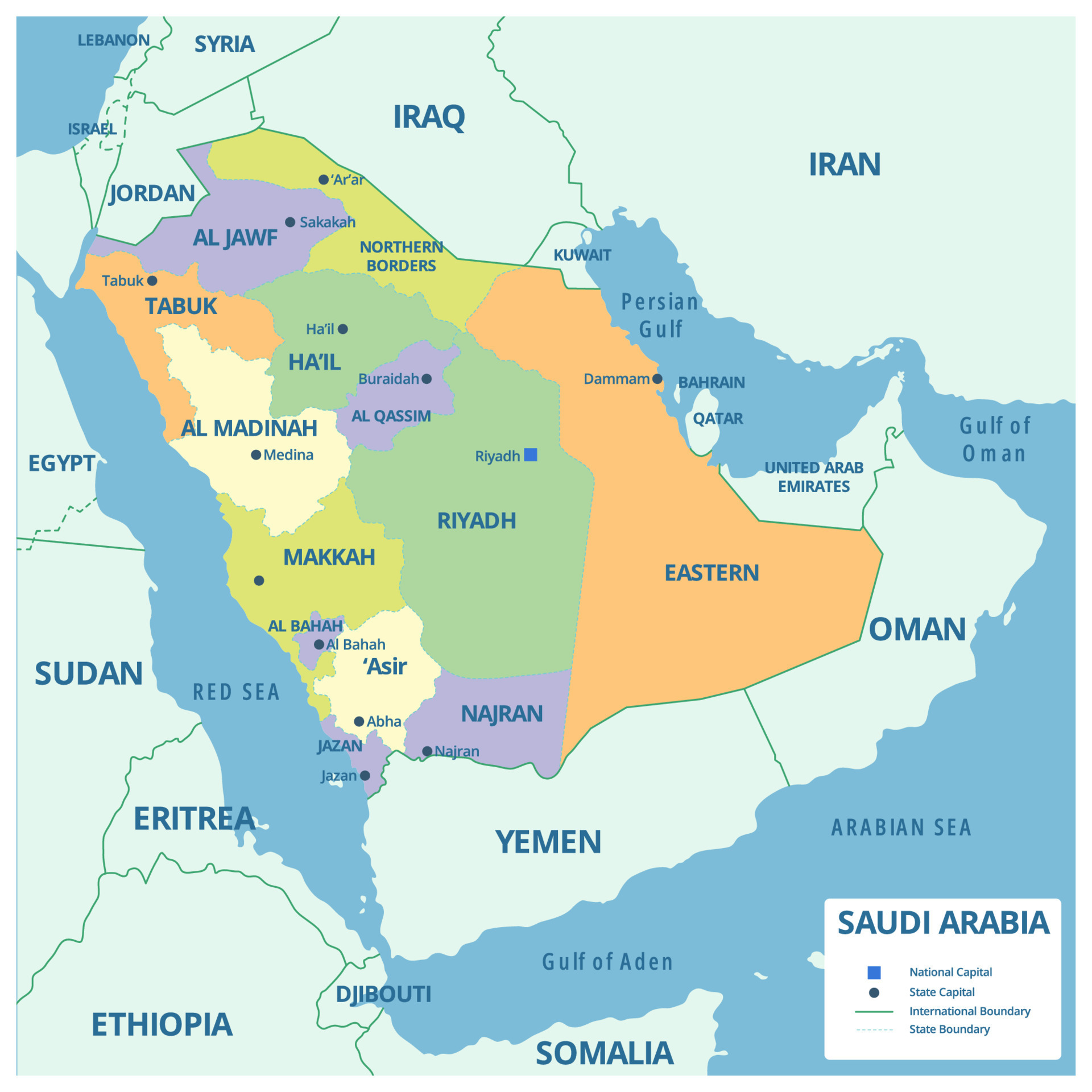
Saudi Arabia occupies roughly 80 percent of the Arabian Peninsula, anchoring the southwest corner of Asia where three continents converge. If you look at a map of the Middle East, the Kingdom forms a massive land bridge between the Red Sea to the west and the Persian Gulf to the east. This exact positioning turns the country into a critical transit point for global shipping lanes, international commerce, and energy transport.
Bounded by seven different countries and two major bodies of water, the Kingdom's geographic coordinates span roughly from 16° to 32° north latitude and 34° to 56° east longitude. Spanning approximately 2.15 million square kilometers, it stands as the largest sovereign state in Western Asia by land area. Understanding its exact layout requires looking past general regional descriptions to examine specific borders, maritime access, terrain barriers, and economic corridors.
Exact Borders and Regional Neighbors
The Kingdom shares land borders with seven nations, creating complex geopolitical dynamics across different fronts.
- Northern Borders: Jordan, Iraq, and Kuwait sit along the northern boundary. The border with Iraq spans over 800 kilometers, while the shorter frontier with Jordan connects the Arabian landmass to the Levant.
- Eastern Borders: Qatar juts out as a peninsula into the Persian Gulf along Saudi Arabia's eastern flank, connected by a single land border crossing. Further south, the United Arab Emirates shares a long southeastern border.
- Southern Borders: Oman forms the border along the southeastern desert expanses, while Yemen stretches across the entire southern boundary along rugged terrain and coastal strips.
Each of these frontier zones presents distinct geographic and security characteristics. The northern desert boundaries historically accommodated nomadic pastoral migration routes, while modern highways now link Riyadh and major northern hubs directly to Amman and Baghdad.
Maritime Access and Global Trade Routes
Water access defines much of the nation's economic leverage. The western coastline stretches for roughly 1,800 kilometers along the Red Sea, providing direct access to the Bab el-Mandeb strait and the Suez Canal. This marine corridor handles a massive share of global container traffic moving between Europe, Asia, and East Africa.
On the eastern side, the coastline along the Persian Gulf connects the country to vital oil transit routes. The shallow waters of the Gulf host major energy export terminals, including Ras Tanura—one of the largest oil-loading facilities on earth. Tankers depart from these eastern ports, navigating through the narrow Strait of Hormuz to supply petroleum to global markets across Asia, Europe, and the Americas.
Terrain and Internal Geography
The interior of the country is far from uniform, featuring a dramatic mix of mountain ranges, coastal plains, and hyper-arid sand seas.
The western highlands feature the Sarat Mountains, running parallel to the Red Sea. Elevations in this region rise sharply, with peaks in the Asir province reaching over 3,000 meters. These highlands experience cooler temperatures and higher precipitation than the rest of the country, supporting agriculture and historical settlement clusters like Abha.
Moving eastward from the highlands, the terrain flattens into the Najd plateau, the historical heartland where the capital city of Riyadh sits. The plateau gradually slopes downward toward the Persian Gulf coastal lowlands, known as the Eastern Province.
To the south and southeast lies the Rub' al Khali, or the Empty Quarter. Covering roughly 650,000 square kilometers, it forms the largest continuous sand desert in the world. Shifting dunes reach heights of up to 250 meters, creating a formidable geographic barrier that historically limited travel between the central plateau and the southern Arabian coast.
Climate and Population Distribution
Geography dictates how humans inhabit this vast landscape. The climate is overwhelmingly arid and desert-like, characterized by extreme summer daytime temperatures often exceeding 45 degrees Celsius (113 degrees Fahrenheit), contrasted with mild winters in the central and northern zones. Rainfall is sparse across most of the territory, forcing cities to rely heavily on coastal desalination plants for municipal water supplies.
Consequently, population distribution mirrors water availability and economic infrastructure:
- Urban Centers: Over 80 percent of the population lives in urban areas. Riyadh serves as the administrative core, while Jeddah functions as the commercial and maritime capital on the Red Sea.
- The Eastern Province: Cities like Dammam, Dhahran, and Khobar concentrate around the oil industry and industrial manufacturing.
- The Western Province: Mecca and Medina anchor the Hejaz region, drawing tens of millions of religious pilgrims annually for the Hajj and Umrah.
Frequently Asked Questions
What continent is Saudi Arabia in?
Saudi Arabia is located in Western Asia, occupying the majority of the Arabian Peninsula. It sits at the intersection where Asia meets Africa, separated from the African continent by the narrow Red Sea.
Which bodies of water border Saudi Arabia?
The country is bordered by the Red Sea to the west and the Persian Gulf to the east. These two coastlines provide the nation with dual maritime access to international shipping routes.
How many countries share a land border with Saudi Arabia?
Seven countries share land borders with the Kingdom: Jordan, Iraq, and Kuwait to the north; Qatar and the United Arab Emirates to the east; and Oman and Yemen to the south.
What is the largest desert inside Saudi Arabia?
The Rub' al Khali, or Empty Quarter, covers the southern third of the country. It is the largest continuous sand desert on Earth, spanning parts of Oman, Yemen, and the UAE as well.
Why is the geographic location of Saudi Arabia strategically important?
Its position between the Red Sea and the Persian Gulf places it at the center of global energy transit and maritime trade routes connecting Asia, Europe, and Africa. Additionally, its central location in the Islamic world makes it a focal point for international diplomacy and religious pilgrimage.



