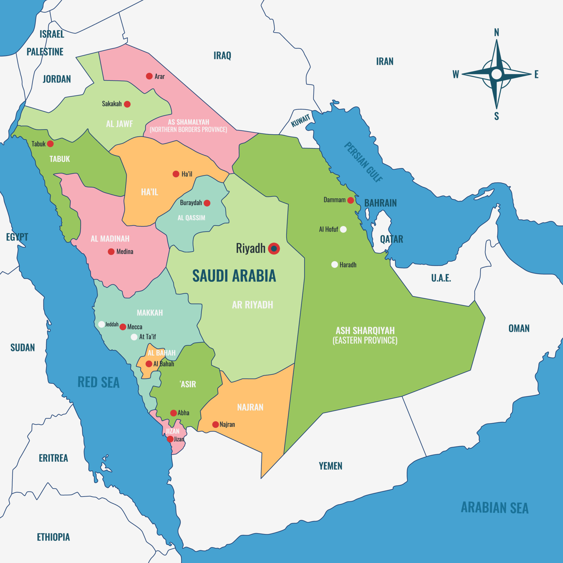
Saudi Arabia occupies roughly eighty percent of the Arabian Peninsula, dominating the landmass situated in Western Asia. If you look at a regional map, it sits at the crossroads of three continents—Asia, Africa, and Europe—making it a historically vital trade hub. It's bounded by major bodies of water on two sides and shares land borders with seven distinct nations.
Understanding where the country sits involves looking closely at its coordinates, regional neighbors, internal terrain zones, and strategic positioning. Let's break down the exact geographical makeup of the kingdom without fluff.
Exact Geographical Coordinates and Continental Position
Geographically, Saudi Arabia is positioned in the Middle East, specifically in Western Asia. Its continental coordinates span roughly between latitudes 16°N and 33°N, and longitudes 34°E and 56°E.
It forms the vast majority of the Arabian Peninsula, stretching across approximately 2.15 million square kilometers (about 830,000 square miles). This makes it the largest sovereign state in the Middle East by land area and the second-largest in the entire Arab world after Algeria.
Surrounding Bodies of Water and Coastlines
Water boundaries define a massive portion of the kingdom's perimeter, offering critical maritime routes for global trade and energy shipping.
The Red Sea to the West
The western border of Saudi Arabia runs along the Red Sea for roughly 2,640 kilometers (1,640 miles). This coastline provides access to the Suez Canal shipping route to the north and the Bab-el-Mandeb strait to the south. Across the water lie African nations including Egypt, Sudan, and Eritrea.
The Persian Gulf to the East
To the east, the country features a shorter coastline of about 500 kilometers (310 miles) along the Persian Gulf. This body of water connects the nation to vital petroleum export channels and faces neighboring states like Iran across the water.
Land Neighbors and International Borders
Saudi Arabia shares its land boundaries with seven countries across the Middle East, spanning a total land boundary length of over 4,400 kilometers.
- Northern Borders: Jordan and Iraq form the northern frontier. Jordan touches the northwest corner near the Gulf of Aqaba, while Iraq spans a long northeast boundary.
- Eastern Borders: Kuwait, Qatar, and the United Arab Emirates sit along the eastern coast and the Persian Gulf basin. Qatar shares a short land border on a peninsula jutting into the Gulf, while Bahrain is connected to the eastern province via the King Fahd Causeway.
- Southern and Southeastern Borders: Oman lies to the southeast, and Yemen runs along the entire southern and southwestern border.
According to data compiled by World Atlas, Yemen accounts for the longest single land border share at roughly 1,458 kilometers, followed by Iraq and Jordan.
Major Internal Regions and Topography
The terrain of Saudi Arabia is far from uniform, split into distinct geographical zones shaped by arid conditions, plateau formations, and coastal mountain ranges.
The Central Najd Plateau
Riyadh, the capital city, sits squarely in the center of the country on the Najd plateau. This region features rocky uplands, ancient dry riverbeds known as wadis, and expanding urban centers.
Major Deserts
The landscape is heavily defined by massive sand and gravel deserts.
- The Rub al-Khali (Empty Quarter): Located in the southern third of the country, this is the largest continuous sand desert in the world, spanning hundreds of thousands of square kilometers of towering dunes.
- An-Nafud: Located in the northern part of the country, this desert is known for dramatic crescent-shaped sand dunes and harsh winds.
Western Mountains (Hejaz and Asir)
Along the western edge near the Red Sea, the terrain elevates sharply into the Hejaz and Asir mountain ranges. Jabal Sawda, near the southwestern city of Abha, is the highest peak in the country, rising over 3,100 meters (10,279 feet) above sea level.
Strategic Location and Global Significance
The location of Saudi Arabia has placed it at the center of international commerce for millennia. Historically, it controlled major overland incense and spice trade routes linking ancient civilizations.
Today, its position bridging three continents allows air traffic to connect the Americas and Europe with Asia and Oceania efficiently. Furthermore, its placement adjacent to key maritime chokepoints gives it profound weight in global energy supply chains and shipping logistics, a dynamic detailed further in overviews by the Encyclopaedia Britannica.
Common Misconceptions About Saudi Arabia's Geography
When people study maps of the Middle East, several recurring points cause confusion.
- Confusing Peninsula Size: Some assume Saudi Arabia covers the entire Arabian Peninsula. While it covers about 80% of it, nations like Oman, Yemen, the UAE, Qatar, Kuwait, and Bahrain occupy the remaining coastal and southern sectors.
- Assuming Year-Round River Systems: Because of the hyper-arid climate, Saudi Arabia has no permanent, flowing natural rivers. Water supply relies heavily on deep underground fossil aquifers, advanced desalination plants along both coasts, and seasonal flash floods in mountain wadis.
- Misidentifying Continental Belonging: Though it shares close historical and cultural ties with North African Arab states, the entire peninsula rests strictly within the continent of Asia.
Frequently Asked Questions
What is the capital of Saudi Arabia?
The capital is Riyadh, located in the central Najd region. It functions as the political, administrative, and financial heart of the nation.
Does Saudi Arabia touch the Mediterranean Sea?
No. Saudi Arabia is bounded by the Red Sea to the west and the Persian Gulf to the east. It has no coastline along the Mediterranean.
How many countries border Saudi Arabia?
Seven countries share land borders with Saudi Arabia: Jordan, Iraq, Kuwait, Qatar, the United Arab Emirates, Oman, and Yemen.
What is the largest desert inside Saudi Arabia?
The Rub al-Khali, or the Empty Quarter, is the largest desert within its borders, covering much of the southern region with vast sand seas.



