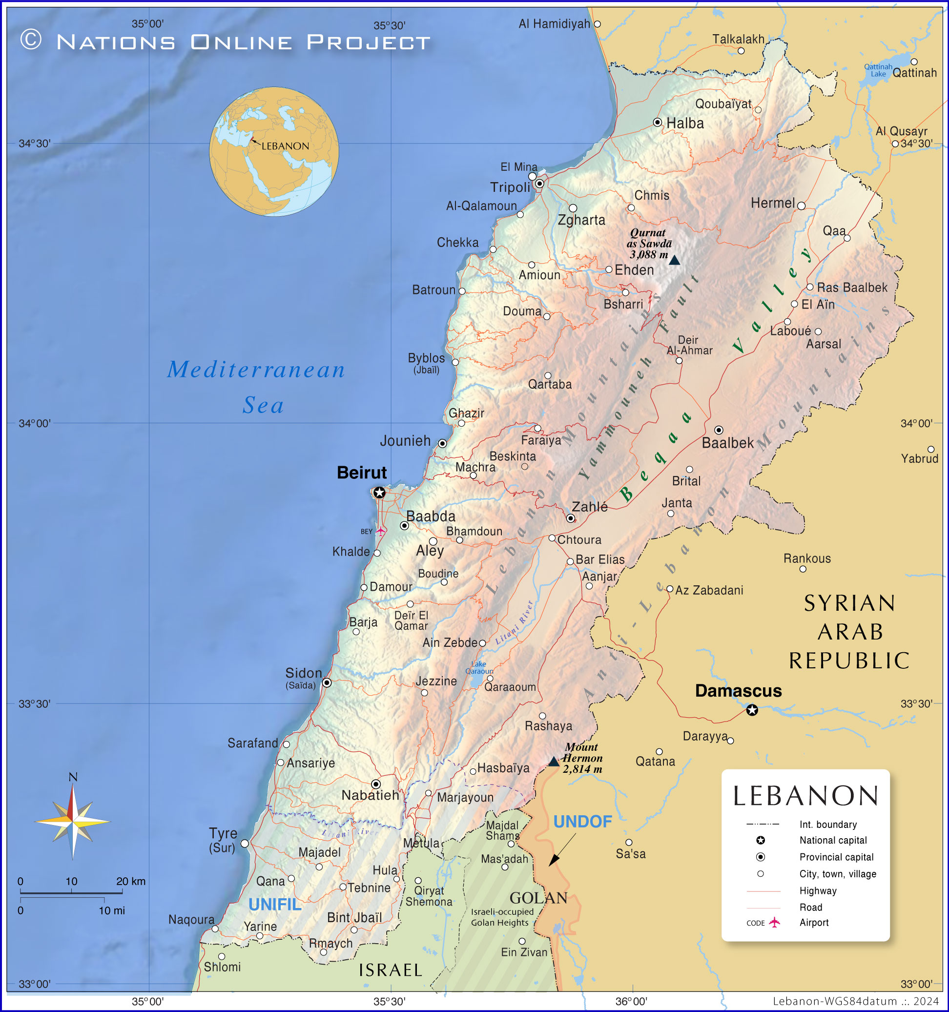
Lebanon is situated in Western Asia, occupying a narrow strip of land along the eastern coast of the Mediterranean Sea. It lies within the heart of the Levant region, bordered by Syria to the north and east, Israel to the south, and the Mediterranean Sea to the west. Its central coordinates are approximately 33.8547° N latitude and 35.8623° E longitude, positioning it at a historic maritime and terrestrial crossroads connecting Europe, Asia, and Africa.
Understanding where Lebanon is located requires looking beyond simple political borders. The nation's total land area covers 10,452 square kilometres, making it one of the smallest sovereign states on the mainland Asian continent. Yet, its physical layout features striking topographical contrast, packed tightly between coastal marine plains and rugged mountain ranges that have shaped its climate, culture, and history for millennia.
Exact Boundaries and GPS Coordinates
The geographical footprint of Lebanon is compact, defined by distinct natural and political dividing lines. Its total land boundaries measure 454 kilometres, split between Syria to the north and east (375 km) and Israel to the south (79 km). To the west, the country opens entirely to 225 kilometres of coastline along the Mediterranean Sea.
- Latitude and Longitude: Centered near 33.85° N, 35.86° E.
- Northernmost Point: Near the border village of Al-Qouaiat.
- Southernmost Point: Near Naqoura on the Mediterranean coast.
- Easternmost Point: Along the crest of the Anti-Lebanon mountain range.
Because of these precise parameters, travelers and logistics planners find that Lebanon acts as a direct bridge between the Levant and the wider Mediterranean basin.
Topography and Land Zones
You can't grasp Lebanon's location without understanding its four distinct parallel longitudinal terrain zones running north to south. These bands dictate everything from local weather patterns to human settlement.
- The Coastal Strip: A narrow, fertile plain known locally as the sahil. It hugs the sea, widening slightly near cities like Tripoli and Beirut, and hosts the majority of the country's urban population and agricultural greenhouse production.
- Mount Lebanon Range: Rising abruptly behind the coastal plain, these limestone peaks climb sharply. The highest point in the entire country, Qurnat as Sawda', reaches an elevation of 3,088 meters.
- The Beqaa Valley: Tucked between two major mountain ranges, this high-altitude plateau sits roughly 900 meters above sea level. It serves as Lebanon's agricultural powerhouse, nourished by the Litani and Orontes rivers.
- The Anti-Lebanon Range: Running parallel to Mount Lebanon along the eastern border with Syria, this dry, rugged chain culminates at Mount Hermon on the southern frontier.
Strategic Position in the Levant
Historically and economically, Lebanon's placement within the Levant gave it outsized influence in regional trade. According to historical data documented by the Library of Congress Country Studies, Phoenician merchants utilized the secure natural indentations of the coast to launch maritime expeditions across the Mediterranean long before modern nation-states emerged.
Today, this spot bridges maritime trade routes moving freight between European ports and Middle Eastern inland markets. While land borders to the south remain strictly controlled and closed for transit, maritime routes keep the nation connected to international shipping lanes.
Common Misconceptions About Lebanon's Geography
- It is part of the Gulf states: Geographically, Lebanon is hundreds of miles away from the Arabian Peninsula's oil-rich Gulf states, belonging instead to the Eastern Mediterranean Levant subregion.
- It has a desert climate: While neighboring regions feature vast arid deserts, Lebanon features a classic Mediterranean climate with wet, cool winters and hot, dry summers, supporting snow-capped ski resorts just miles from warm beaches.
- It is large in land area: Many assume Middle Eastern nations span massive territories; Lebanon ranks among the smallest, taking less driving time to cross end-to-end than most US states or European provinces.
Frequently Asked Questions
What continent is Lebanon in?
Lebanon is located in Western Asia, commonly referred to as the Middle East. Its immediate neighbors on the Asian continent are Syria and Israel.
What is the capital city of Lebanon and where is it located?
The capital is Beirut, positioned centrally along the country's Mediterranean coastline. It functions as the primary commercial hub and major seaport.
Can you drive across Lebanon easily?
Yes. Because the total north-to-south length is roughly 225 kilometers and the width varies between 32 and 88 kilometers, driving across the country takes only a few hours depending on traffic and mountain routes.
Does Lebanon share any water borders other than the Mediterranean?
No. Aside from its 225-kilometer western coastline facing the Mediterranean Sea, Lebanon is entirely land-bound by Syria and Israel.



