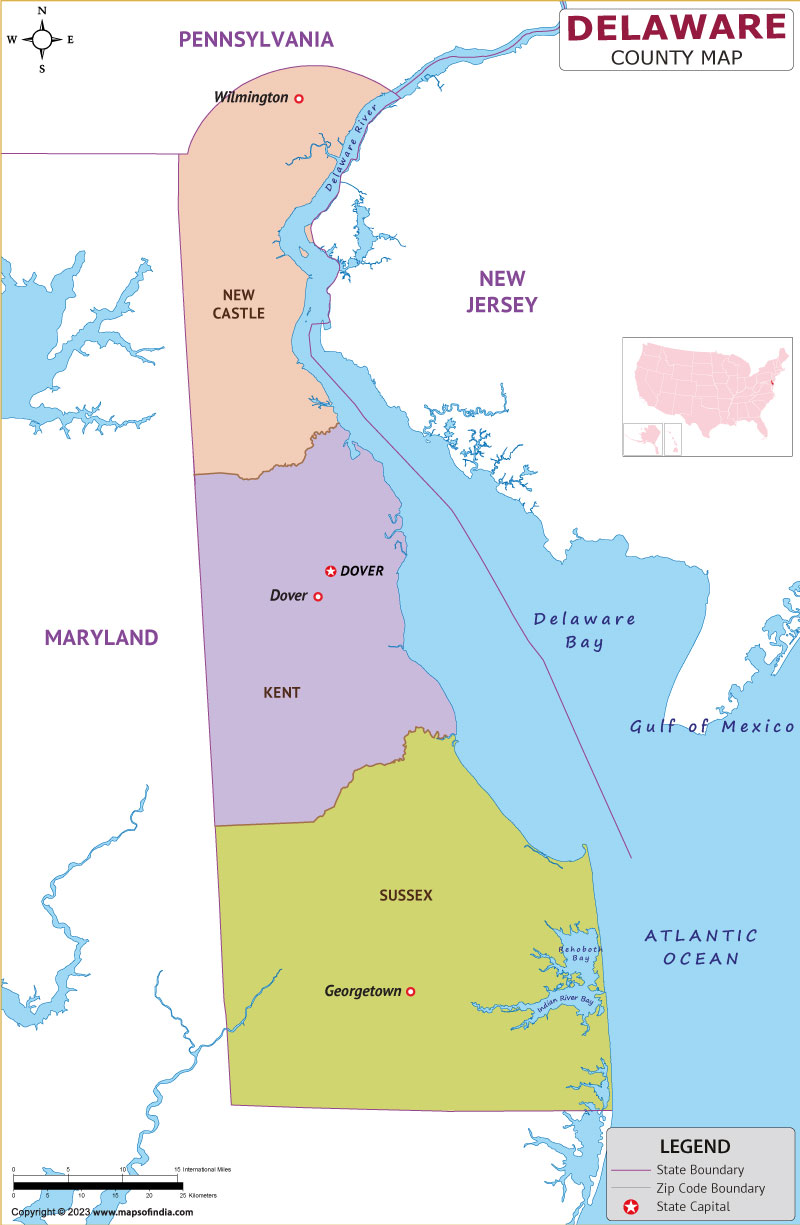
Delaware sits along the Mid-Atlantic seaboard of the United States, occupying the northeastern portion of the Delmarva Peninsula. It's bordered by Pennsylvania to the north, Maryland to the west and south, New Jersey and the Delaware River/Bay to the east, and the Atlantic Ocean along its southeast coast. Despite being the second-smallest state by area at roughly 2,489 square miles, it packs immense economic and historical weight into a compact space, housing major corporate headquarters and serving as a vital link in the Boston-Washington corridor.
Understanding Delaware requires looking beyond its small footprint on a map. From its colonial roots to its status as the corporate capital of America, this Mid-Atlantic hub commands attention.
Geographic Layout and Boundaries
Delaware measures just 96 miles long and ranges from 9 to 35 miles across. It's organized into three counties from north to south: New Castle, Kent, and Sussex. Each county introduces a distinct terrain and economic focus.
- New Castle County: The northernmost tip features rolling hills belonging to the Piedmont plateau. This is where you'll find Wilmington, industrial hubs, and the state's highest point at Ebright Azimuth (448 feet).
- Kent County: Located in the center, this region houses the state capital of Dover. The landscape shifts to flat coastal plains, mixing agricultural fields with government installations.
- Sussex County: The southern expanse dominates the Delmarva Peninsula, featuring flat sandy soils, intensive poultry farming, and popular beach towns like Rehoboth Beach along the Atlantic coastline.
The state's eastern water boundary is unique. Through historical colonial land grants, Delaware owns the entire width of the Delaware River up to the low-water mark on the New Jersey shore within the famous Twelve-Mile Circle, creating unusual border anomalies where small patches of land on the New Jersey side technically belong to Delaware.
The First State: Historical Origins
Delaware earned its famous nickname—The First State—on December 7, 1787, when its convention unanimously voted (30-0) to ratify the United States Constitution. It was the first of the original thirteen colonies to do so, setting a decisive precedent that encouraged lagging states to support the new federal government.
Before European arrival, the region was inhabited by Algonquian-speaking Native Americans, primarily the Unami Lenape in the north and the Nanticoke in the south. Dutch and Swedish colonists established early rival settlements in the 1600s—including Zwaanendael and Fort Christina—before English control took permanent hold under William Penn's proprietary claims.
During the American Civil War, Delaware occupied a complex geopolitical position. Though it was legally a slave state, it remained loyal to the Union and did not secede, reflecting its economic and cultural ties to both northern industrial centers and southern agricultural traditions.
Modern Economic Relevance
Today, Delaware's influence stretches far beyond its physical boundaries. Four of the ten largest U.S. cities lie within 150 miles of its borders, placing it at the heart of the Northeast megalopolis.
Corporate and Legal Capital
More than half of all publicly traded companies in the United States—including a massive share of Fortune 500 firms—are incorporated in Delaware. Businesses choose Delaware because of its Court of Chancery, a specialized court system that handles corporate disputes without juries, relying on judges with deep expertise in business law. The state's General Corporation Law provides predictable, stable legal frameworks that boards and investors prefer.
Regional Industries
While corporate law drives state revenue, physical manufacturing and agriculture anchor local jobs.
- Chemicals and Manufacturing: Wilmington became an early pioneer in industrial chemistry, famously boosted by the DuPont Company, which established gunpowder and chemical processing mills along the Brandywine Creek.
- Agriculture: Poultry farming is Sussex County's economic engine, supported by extensive soybean and corn production.
- Tourism: Millions of visitors flock to Delaware's Atlantic coastline each summer, driving a robust hospitality and retail sector in coastal communities.
Common Misconceptions About Delaware
People often misunderstand several aspects of the state's geography and governance:
- Capital Confusion: Many assume Wilmington is the capital because it's the largest city. In reality, Dover serves as the capital and center of state government operations.
- Not an Island: Because it sits on the Delmarva Peninsula, casual map readers sometimes mistake it for an island separated entirely from the mainland, ignoring its direct land borders with Maryland and Pennsylvania.
- Tax Myth: While corporate laws are highly favorable, Delaware residents still pay standard state income and property taxes; incorporation tax benefits primarily apply to registered businesses rather than everyday individual residents.
Frequently Asked Questions
Why is Delaware called the First State?
It received this title because it was the first colony to ratify the United States Constitution on December 7, 1787.
What states share a border with Delaware?
Delaware shares land borders with Pennsylvania to the north and Maryland to the west and south. It also meets New Jersey across the Delaware River and Bay to the east.
Why do so many companies incorporate in Delaware?
Companies register in Delaware to utilize its predictable Court of Chancery, flexible corporate statutes, and well-established body of business case law that protects corporate governance structures.
What is the primary geographic feature of southern Delaware?
Southern Delaware consists primarily of flat coastal plains and low-lying marshlands that make up the northern neck of the Delmarva Peninsula, heavily supporting agriculture and beach tourism.



