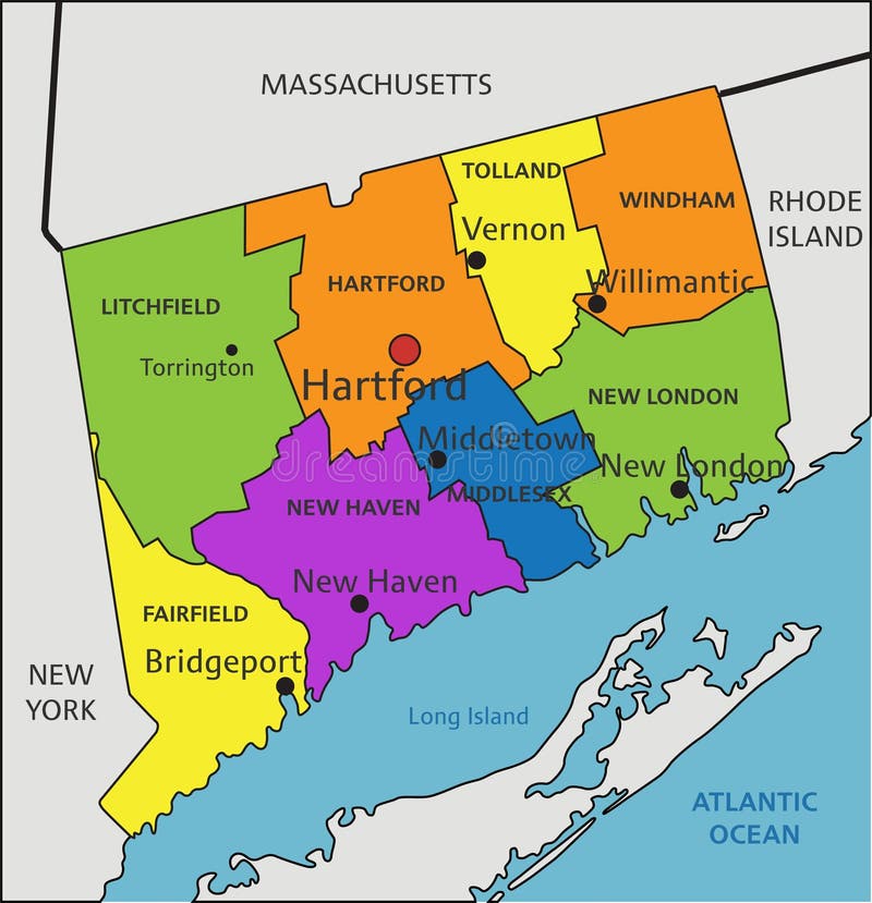
Mapping the precise location of Connecticut requires looking at the northeastern corner of the United States, where the state anchors a vital economic and cultural bridge between New York and the rest of New England. Officially known as the Constitution State, it spans roughly 5,543 square miles, making it the third-smallest state by area but an outsized player in regional transit, history, and commerce.
Understanding where Connecticut sits on the map involves more than just reciting its bordering neighbors. Its unique geography places it squarely inside the dense Northeast megalopolis, turning local boundaries into high-traffic corridors that millions of commuters navigate daily.
Precise Geographical Location of Connecticut
Connecticut is positioned in the New England region of the United States. On a standard national map, it appears in the lower left corner of the six New England states, acting as a geographical gateway between New York City and Boston.
The state's exact borders are defined by four distinct geographic touchpoints:
- North: Shares a border with Massachusetts (specifically the Springfield and Worcester regions).
- South: Bounded entirely by the Long Island Sound, which separates the mainland from Long Island, New York, before opening into the Atlantic Ocean.
- East: Borders Rhode Island, terminating at the Pawcatuck River and a straight northward line.
- West: Borders New York State, with its westernmost panhandle reaching uncomfortably close to New York City's northern suburbs.
According to data from the U.S. Census Bureau, the state's coordinates center roughly around 41.6032° N, 73.0877° W. Despite its compact footprint—spanning only about 90 miles east-to-west and 55 miles north-to-south—its internal terrain shifts dramatically from the rolling Litchfield Hills in the northwest to the coastal marshes lining Long Island Sound.
Why It Is Called the Constitution State
The moniker "Constitution State" stems from deep historical roots that tie its physical location to the foundational governance of the United States. In 1639, settlers in Hartford, Wethersfield, and Windsor drafted the Fundamental Orders of Connecticut. Historians widely recognize this document as the first written constitution in Western history that created a government distinct from religious authority.
When delegates gathered for the Constitutional Convention of 1787, Connecticut's leaders proposed the Great Compromise, which balanced power between large and small states by creating a bicameral legislature. On January 9, 1788, Connecticut became the fifth state to ratify the federal U.S. Constitution. Its regional mapping and political identity have remained tied to constitutional history ever since.
Regional Significance in the Northeast Megalopolis
Connecticut's location isn't just a matter of cartography; it drives the economy of the entire northeastern seaboard. Positioned directly between New York City and Providence or Boston, the state functions as a critical transit funnel.
Transportation and Commuter Corridors
The Merritt Parkway and Interstate 95 carve through the southwestern coastal shelf, carrying hundreds of thousands of vehicles daily. Metro-North Railroad lines move massive waves of workers from towns like Stamford and Greenwich straight into Grand Central Terminal. This geographic proximity to New York City shapes local real estate markets, labor pools, and municipal economies.
Economic Hubs and Industry Clusters
While the southwestern tier leans heavily on financial services and corporate headquarters linked to New York, the central and eastern regions maintain distinct industrial identities:
- Hartford: Historically recognized as the insurance capital of the world, anchored near the banks of the Connecticut River.
- Groton: Home to major defense manufacturing, including Electric Boat, where U.S. Navy submarines are built.
- New Haven: Centered around Yale University, driving biotechnology and medical research sectors.
You can explore detailed regional data and official state resources directly through the State of Connecticut Official Website.
Common Misconceptions About Connecticut's Geography
Cartographers and travelers often run into a few recurring errors when mapping or discussing the state:
- Assuming it is part of the New York Tri-State suburban sprawl entirely: While Fairfield County is heavily integrated with New York commuter culture, eastern and northwestern Connecticut feel much more like rural New England, featuring dense forests, covered bridges, and quiet agricultural valleys.
- Confusing the capital with the largest city: Many assume Bridgeport or Hartford holds the title for both population and governance. While Hartford is the capital, Bridgeport boasts the highest population within municipal borders.
- Misjudging coastline access: Because Long Island shields the southern border, the state lacks direct, crashing Atlantic Ocean surf. Instead, its shoreline consists of protected sounds, tidal estuaries, and salt marshes.
Frequently Asked Questions
What time zone is Connecticut in?
Connecticut observes Eastern Standard Time (EST) during the winter and Eastern Daylight Time (EDT) during the summer, matching New York, Boston, and Washington, D.C.
Is Connecticut part of the tri-state area?
Yes. Connecticut forms part of the tri-state area alongside New York and New Jersey, particularly regarding the metropolitan influence of New York City.
How many counties does Connecticut have?
Connecticut has eight counties—Fairfield, New Haven, Hartford, New London, Middlesex, Tolland, Litchfield, and Windham. However, county governments were abolished in 1960, leaving local towns and cities to handle municipal governance.
What is the highest point in Connecticut?
The highest natural elevation is Bear Mountain in the town of Salisbury, reaching 2,316 feet above sea level in the extreme northwestern corner of the state.



