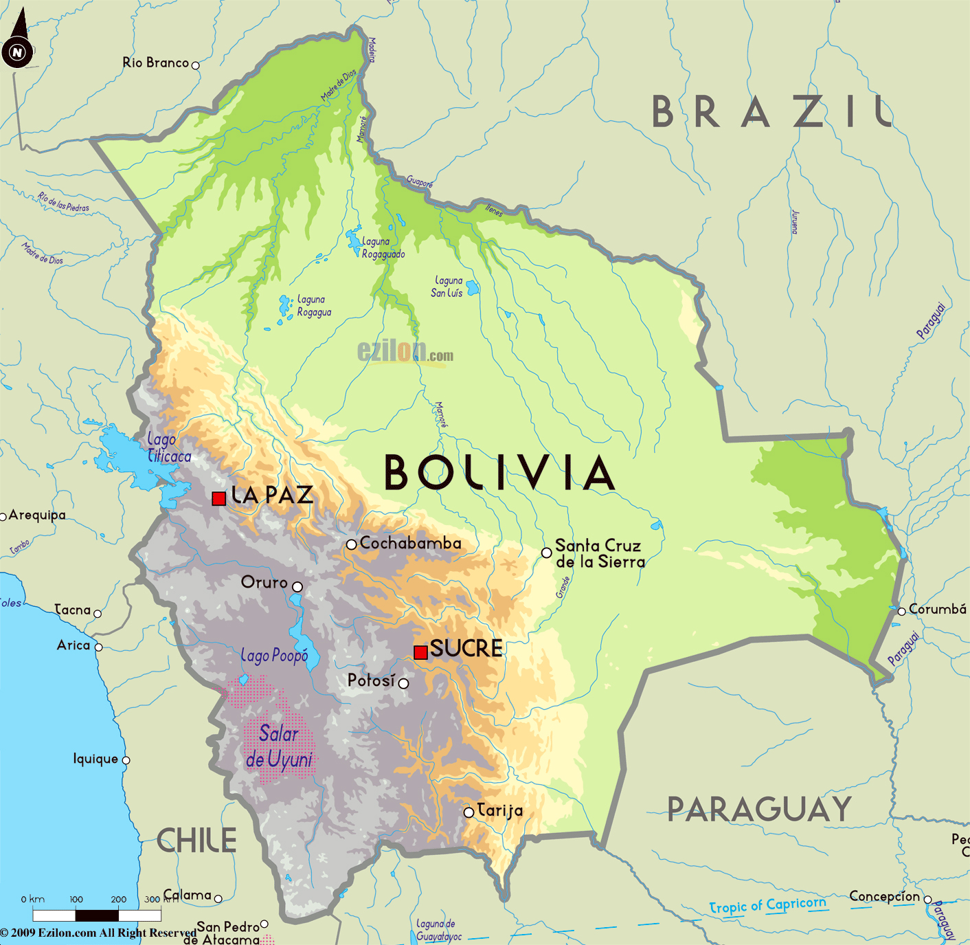
Bolivia sits right in the central part of South America, acting as a vital land bridge across the continent. Because it is completely landlocked, it doesn't touch any ocean, sharing its vast interior space instead with five neighboring countries.
Understanding where Bolivia is located requires looking past simple coordinates on a map. It spans high Andean peaks, transitional valleys, and the western edge of the Amazon Basin, shaping a unique crossroad of cultures and ecosystems.
Immediate Neighbors and Borders
Bolivia shares borders with five distinct nations, totaling more than 6,700 kilometers of land boundaries. Each border links the country to a different cultural and economic sphere within South America.
- Brazil: Stretching across the north and east, Brazil forms Bolivia's longest border. This vast expanse connects the Bolivian lowlands to major agricultural and trade networks.
- Peru: To the west, the border runs through the high Andes and cuts straight through Lake Titicaca, the highest navigable body of water in the world.
- Chile: Running along the southwest, the Chilean border separates Bolivia from the Pacific coast. This border holds deep historical significance because Bolivia lost its sovereign coastline during the War of the Pacific in the late 19th century.
- Argentina: To the south, the boundary transitions from rugged mountain passes down into rolling agricultural plains, fostering deep migration and trade links.
- Paraguay: To the southeast, the border cuts through the semi-arid Gran Chaco region, a flat and sparsely populated expanse rich in natural resources.
To explore official regional data and international relations, you can consult insights from the World Bank or general geopolitical profiles on Encyclopaedia Britannica.
Distinct Geographic Zones
You can't grasp Bolivia's location without looking at its extreme vertical landscape. The country splits into three major ecological zones that dictate where people live and how the economy functions.
The Andean Highlands and the Altiplano
The western third of Bolivia is dominated by the Andes mountain range. Here, you'll find the Altiplano, a high-altitude plateau sitting roughly 3,700 meters above sea level. This thin-air environment hosts La Paz, the administrative capital, along with cold deserts, volcanic peaks, and vast salt flats like the Salar de Uyuni.
The Sub-Andean Valleys
Dropping down the eastern slopes of the Andes brings you to the Yungas and temperate valley regions. This transitional zone features steep canyons, rushing rivers, and mild climates. Cities like Sucre—the constitutional capital—sit comfortably in these sheltered basins, benefiting from fertile soils and moderate temperatures.
The Lowlands and Amazon Basin
Covering over half of the country's total land area, the eastern lowlands are flat, hot, and humid. This region includes the Amazon rainforest basin in the north and the tropical savannas of the Beni department. It's a rapidly growing agricultural frontier focused on cattle ranching and soybean production.
Common Misconceptions About Bolivia's Location
Travelers and students often make a few specific errors when visualizing Bolivia on a map.
- Assuming it touches the sea: Many people forget that Bolivia lost its coastline to Chile in the 19th century, making it one of only two landlocked countries in South America, alongside Paraguay.
- Confusing the capitals: Because Bolivia has two capitals—La Paz as the administrative seat and Sucre as the judicial center—people frequently pin the entire government machinery to a single city.
- Picturing only mountains: While the Andes define its western identity, the majority of Bolivian territory actually consists of tropical lowlands and rainforests.
Frequently Asked Questions
Is Bolivia completely landlocked?
Yes. Bolivia lost direct access to the Pacific Ocean following the War of the Pacific in 1884. It relies on transit agreements with neighboring ports in Chile, Peru, and Argentina for international shipping.
What are the two capital cities of Bolivia?
Sucre is the constitutional and historical capital, while La Paz serves as the seat of government and administrative capital.
What is the highest elevation point in Bolivia?
Mount Sajama, an extinct stratovolcano located in the western cordillera, stands at 6,542 meters above sea level, making it the highest peak in the country.
Which countries surround Bolivia?
Bolivia is bordered by Brazil to the north and east, Peru and Chile to the west, Argentina to the south, and Paraguay to the southeast.



