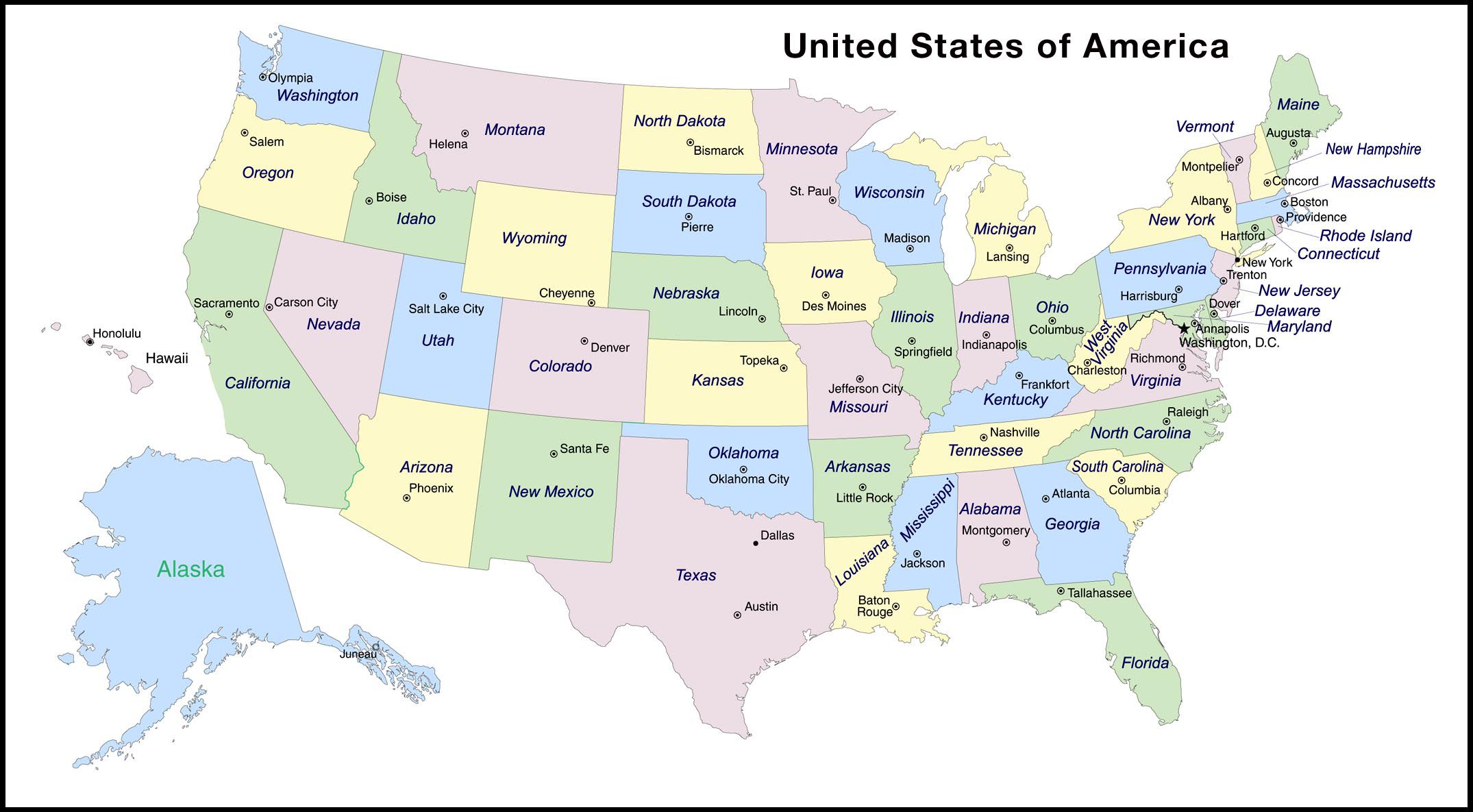
When people talk about the East Coast of the United States, they're usually referring to the sweeping chain of states that touch the Atlantic Ocean, stretching from the rocky shores of Maine down to the subtropical keys of Florida. There are 14 states with direct coastlines on the Atlantic, though the broader cultural and economic region often includes neighboring non-coastal states like Pennsylvania and Vermont.
If you're trying to figure out exactly which states make up this historic corridor, geography breaks them down cleanly from north to south. Let's look at the actual lineup, what defines each sub-region, and the common misconceptions people run into when mapping out America's eastern seaboard.
The 14 States with Direct Atlantic Coastlines
Geographically speaking, the core definition of the East Coast relies entirely on tidal water. Exactly 14 states share a direct border with the Atlantic Ocean. Listed in order from north to south, they are:
- Maine
- New Hampshire
- Massachusetts
- Rhode Island
- Connecticut
- New York
- New Jersey
- Delaware
- Maryland
- Virginia
- North Carolina
- South Carolina
- Georgia
- Florida
While these 14 share the saltwater boundary, the East Coast isn't just a single uniform strip. Culturally, economically, and climatically, it splits into distinct sub-regions that have evolved independently since the colonial era.
Breaking Down the Sub-Regions
Geographers and locals generally divide the eastern seaboard into three major sub-regions: New England, the Mid-Atlantic, and the South Atlantic. Each has its own distinct climate, architecture, and cultural footprint.
New England
Tucked into the northeastern corner of the country, New England is known for its rugged coastlines, colonial history, and rolling hills. This sub-region includes six states, five of which sit directly on the ocean.
- Maine: Famous for its jagged rocky shores, lighthouses, and lobster fisheries.
- New Hampshire: Has a short but busy Atlantic coastline anchored by Portsmouth.
- Massachusetts: A dense economic and historical hub featuring Cape Cod and Boston.
- Rhode Island: The smallest state by area, dominated by Narragansett Bay.
- Connecticut: Features a major shoreline along Long Island Sound, which feeds into the Atlantic.
- Vermont: The lone New England state without an ocean coastline, though it shares the same historical and cultural fabric.
The Mid-Atlantic
Moving south, the Mid-Atlantic states form the nation's financial, political, and media powerhouse. This zone bridges the gap between the northeast and the southern states.
- New York: Home to the nation's largest city and a massive Atlantic coastline spanning Long Island.
- New Jersey: Encircles a heavy mix of barrier islands, major shipping ports, and dense suburbs.
- Pennsylvania: While it doesn't touch the open ocean, it borders the tidal Delaware River estuary, connecting it directly to Atlantic shipping lanes.
- Delaware: Features a compact coastline along the Delaware Bay and the open Atlantic.
- Maryland: Bisected by the Chesapeake Bay, giving it massive tidal exposure tied to the Atlantic ecosystem.
The South Atlantic
As you travel further south, the climate shifts from temperate to subtropical, and the landscape flattens into expansive sandy beaches and marshlands.
- Virginia: Centered around the massive natural harbor of Hampton Roads and the Chesapeake Bay.
- North Carolina: Known for the Outer Banks, a long string of barrier islands shielding the mainland.
- South Carolina: Features historic coastal cities like Charleston and sweeping tidal marshes.
- Georgia: Features a shorter, marsh-heavy coastline dotted with the historic Golden Isles.
- Florida: The southernmost anchor of the region, boasting the longest Atlantic coastline outside of Alaska and a massive peninsula stretching toward the Caribbean.
According to data compiled by the US Census Bureau, these eastern states house over a third of the entire American population, making it one of the most densely populated coastal strips in the world.
Common Confusion: States Often Mistakenly Included
Because regional definitions blur together, people frequently misclassify certain states as part of the East Coast.
- Pennsylvania: People often assume Pennsylvania is entirely landlocked. However, its southeastern corner sits on the Delaware River, which is a tidal estuary flowing directly into Delaware Bay and the Atlantic Ocean. This grants Philadelphia deep-water port access, which is why it's historically grouped with coastal neighbors.
- Washington, D.C.: While it's not a state, the nation's capital sits along the Potomac River—another tidal arm of the Atlantic—and is deeply integrated into the Mid-Atlantic corridor.
- West Virginia: Formed during the Civil War by splitting from Virginia, West Virginia is entirely landlocked in the Appalachian Mountains and has no direct Atlantic access, despite its name.
You can learn more about how geographic boundaries are tracked and mapped via the USGS, which provides detailed geospatial data for all 50 states.
Common Mistakes When Studying the Seaboard
When people map out or write about the Atlantic seaboard, a few typical errors pop up repeatedly:
- Confusing the East Coast with the Eastern Time Zone: The Eastern Time Zone stretches far inland into states like Ohio, Michigan, Indiana, and parts of Tennessee and Kentucky. None of those inland states are on the East Coast.
- Forgetting Island Territories: Puerto Rico and the U.S. Virgin Islands sit in the Atlantic basin, but they are Caribbean territories, not part of the continental East Coast states.
- Treating Coastline Length as State Size: Just because a state is large geographically doesn't mean it has a massive ocean shoreline. Georgia, for instance, has a surprisingly short coast relative to its total area because of how state boundaries were drawn historically.
Frequently Asked Questions
How many states are on the East Coast?
There are 14 states with direct coastlines along the Atlantic Ocean. However, when including landlocked states tightly integrated into the region like Pennsylvania and Vermont, the broader cultural definition often encompasses 16 or 17 states.
Is Pennsylvania considered an East Coast state?
Yes and no. It doesn't touch the open ocean, but it has a vital tidal water connection via the Delaware River, making it a key player in the Mid-Atlantic economic ecosystem.
Which East Coast state has the longest coastline?
Florida has the longest coastline on the Atlantic side, stretching over 1,350 miles when combining its Atlantic and Gulf exposures, though Maine also boasts an intensely long, jagged shoreline due to its thousands of tiny islands and inlets.
What is the difference between the East Coast and the Eastern Seaboard?
They mean the exact same thing. "Eastern Seaboard" is simply a more formal or traditional term for the continuous strip of land bordering the Atlantic Ocean.



