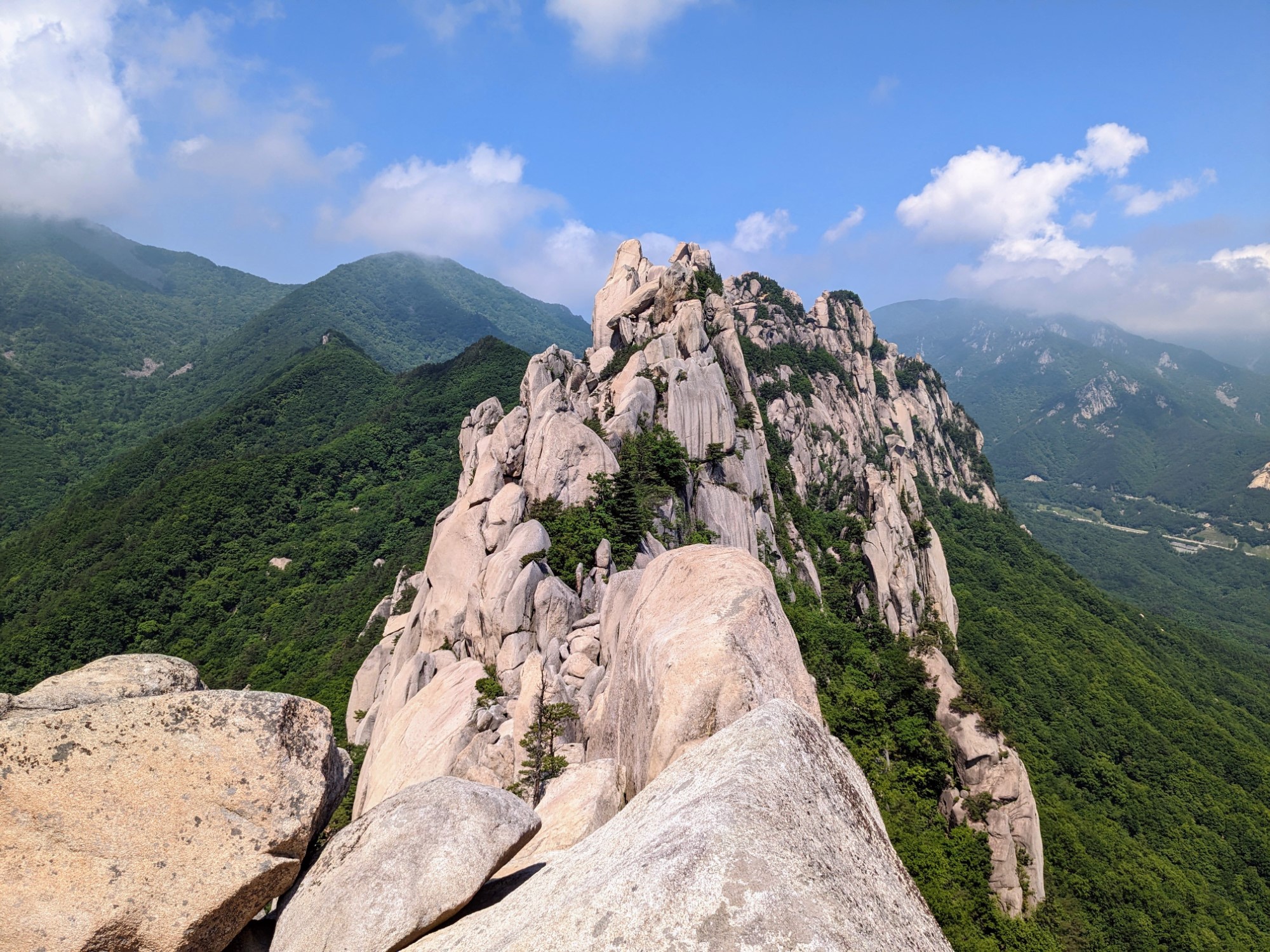
Seoraksan National Park covers roughly 398 square kilometers of South Korea's rugged Taebaek Mountains, featuring granite peaks, cascading waterfalls, and ancient Buddhist temples. Designated as a UNESCO Biosphere Reserve in 1982, the park draws over two million visitors annually, particularly during autumn foliage season and winter snowfalls. Daecheongbong Peak reaches 1,567 meters as the highest point in the park, offering challenging alpine routes for experienced hikers.
Planning a trip here requires understanding complex trail systems, seasonal weather shifts, and logistical entry points from Sokcho. This guide breaks down the essential routes, packing requirements, and practical tips needed to navigate Seoraksan safely and efficiently.
Understanding Seoraksan Geography and Access
Seoraksan is divided into distinct districts, with the outer park (Oe-Seorak) near Sokcho being the most accessible for travelers. The inner park (Nae-Seorak) offers deeper wilderness and fewer crowds, while the southern district (Nam-Seorak) provides access to mineral springs and secondary trailheads.
Most visitors base themselves in Sokcho, a coastal city located a ten-minute bus ride from the main Seoraksan entrance. Express buses run frequently from Seoul's Dong Seoul Terminal or Express Bus Terminal to Sokcho, taking roughly two and a half to three hours.
- Main Entrance (Sogong-ju): The primary hub featuring Sinheungsa Temple, the Bronze Buddha statue, and the cable car station leading to Gwongeumseong Fortress.
- Osaek District: Located on the southern side, ideal for hikers targeting the direct, steep ascent to Daecheongbong Peak.
- Baikdam Temple Entrance: Situated on the western side, serving as the gateway to the quieter inner valleys and remote ridge routes.
Major Hiking Routes and Trails
Choosing the right trail depends entirely on your physical conditioning and time frame. Seoraksan trails range from leisurely valley walks to strenuous, full-day technical climbs.
Ulsanbawi Rock Trail
- Distance: 3.8 kilometers round trip from Sogong-ju
- Duration: 2 to 3 hours
- Difficulty: Moderate to Strenuous
The trail to Ulsanbawi climbs steadily through forest before concluding with an intense series of steep steel staircases bolted directly into the granite rock face. The summit delivers panoramic views of the East Sea and surrounding jagged peaks. It's an accessible option for those who want dramatic mountain scenery without committing to a full-day trek.
Daecheongbong Peak via Osaek
- Distance: 5 kilometers one way
- Duration: 4 to 5 hours uphill
- Difficulty: Very Strenuous
This is the shortest route to the highest peak in the park, but it is relentless. The path consists almost entirely of stone steps and dirt tracks climbing straight up the mountain without switchbacks. While you won't encounter technical rock climbing, the vertical gain tests leg strength and cardiovascular endurance.
Biryong Falls and Towangseong Falls
- Distance: 2.4 kilometers one way
- Duration: 1 to 2 hours round trip
- Difficulty: Easy
A gentle, shaded valley walk following a rushing stream leads to Biryong Falls. Visitors can climb an additional metal observation deck to catch a distant view of Towangseong Falls, a towering three-tiered waterfall plunging down a sheer rock cliff.
Seasonal Timing and Weather Considerations
Seoraksan transforms dramatically across the four seasons, requiring specific gear and preparation for each period.
- Autumn (Late September to Late October): The most popular time to visit, as maple and oak trees turn brilliant shades of red and orange. Trails become heavily congested, and weekend accommodation in Sokcho books out weeks in advance.
- Winter (December to February): Temperatures routinely drop below freezing, and peaks accumulate heavy snow and ice. Hiking requires microspikes or crampons, windproof layers, and early starts due to limited daylight.
- Spring (April to May): Azaleas bloom across lower slopes, and streams swell with snowmelt. Weather is generally stable, though mountain winds remain brisk.
- Summer (June to August): Dominated by the monsoon season, bringing heavy rainfall and humid conditions. Trails can be slippery, and river crossings require caution.
Essential Gear and Park Regulations
Navigating South Korea's national parks involves strict adherence to conservation rules. You won't find trash cans along the trails; visitors must pack out all waste.
- Footwear: Sturdy hiking boots with solid ankle support and high traction are mandatory for granite slab trails.
- Navigation: Download offline map applications like KakaoMap or Naver Maps, as foreign GPS apps often lack detailed trail data in remote Korean mountains.
- Reservations: While general day-hiking doesn't require permits, staying overnight in any of the park's mountain shelters (daecheso) requires booking online weeks in advance through the Korea National Park Service.
- Cash and Cards: Bring Korean Won for park entrance fees (approximately 4,500 KRW for adults visiting temples/parks) and bus fares, though cards are widely accepted in Sokcho.
Frequently Asked Questions
Can I hike Seoraksan in a single day from Seoul?
Yes, but it requires an early start. Catching a 6:00 AM bus from Seoul gets you to Sokcho by 9:00 AM, allowing enough daylight for a moderate hike like Ulsanbawi or Biryong Falls before returning that evening.
Is the Seoraksan cable car operating year-round?
The cable car runs daily, weather permitting. However, it cannot be reserved in advance; tickets are sold on a first-come, first-served basis at the base station, and high winds frequently cause temporary shutdowns.
Are there food and water stations along the hiking trails?
There are restaurants and convenience stores near the main park entrance at Sogong-ju. Once you start hiking deeper into the trails, there are no vendors. You must carry all necessary water and food with you.
What wildlife might I encounter in the park?
Seoraksan is home to the endangered Korean goral, wild boars, and Asiatic black bears. While bears and gorals rarely approach populated trails, hikers should stay on marked paths and store food securely if staying overnight.


