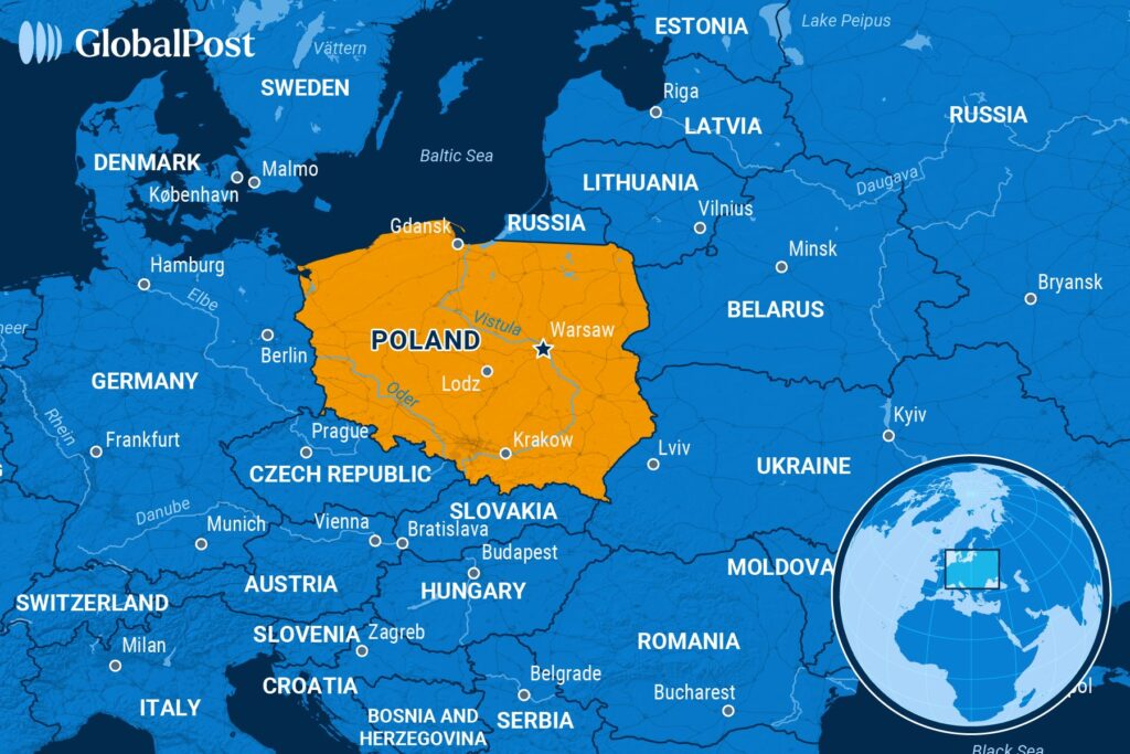
Poland sits right at the geographical crossroads of the European continent, bridging Western industrial markets with Eastern European plains. If you look at a physical map of Europe, it spans roughly from latitudes 49° to 55° N and longitudes 14° to 24° E. This positioning places it firmly in Central Europe, bordered by the Baltic Sea to the north, major mountain ranges to the south, and a flat expanse of lowlands that connects it to both Germany and the Eurasian plain.
Understanding where Poland is situated requires looking beyond simple cardinal directions. For decades, Cold War politics slotted the country into Eastern Europe due to its alignment in the Warsaw Pact. Today, political, economic, and cultural realities place it squarely within Central Europe. It functions as a major transit corridor, a strategic NATO eastern flank member, and the demographic and economic anchor of the European Union's central tier.
Geographical Boundaries and Immediate Neighbors
Poland shares land borders with seven different countries, creating a complex geopolitical perimeter that spans approximately 3,500 kilometers.
- Western Border: Germany borders Poland to the west, defined largely by the Oder and Lusatian Neisse rivers. This 467-kilometer frontier represents one of the country's most heavily integrated economic and transit corridors.
- Southern Border: The Czech Republic and Slovakia sit to the south. Natural barriers dominate this stretch, with the Sudetes and Carpathian mountain ranges (including the Tatra mountains) forming a rugged physical separation.
- Eastern Border: Ukraine and Belarus lie to the east. These borders represent the outer frontier of the European Union and Schengen Area, spanning rolling plains and river basins.
- Northern and Northeastern Border: The Baltic Sea forms Poland's northern coastline, offering roughly 440 kilometers of maritime access. To the northeast, Poland borders Lithuania and the Kaliningrad Oblast, a Russian exclave.
Topography and Landforms
The physical landscape of Poland is dominated by the North European Plain. Over 75 percent of the country's total area lies below 200 meters in elevation.
The terrain rolls from the northern coastal beaches and lake districts (such as the Masurian Lake District) down through the central lowlands, which are carved by major river systems like the Vistula and the Warta. These flat plains made the country historically vulnerable to cross-border invasions, as there are no major natural geographic walls separating central Poland from its eastern and western neighbors.
In contrast, the southern edge spikes upward into ancient uplands and alpine peaks. The highest point is Mount Rysy in the Tatra range, reaching 2,499 meters. This southern boundary creates a distinct microclimate and separates the Polish river basins from the Danube watershed.
Geopolitical and Strategic Significance
Poland's placement in Central Europe transforms it into a vital logistics and security hub. Because major East-West European transport corridors pass through its territory, it acts as a primary land bridge for goods moving between the Baltic states, Scandinavia, Western Europe, and the Black Sea region.
On a broader scale, its location places it at the frontline of European security frameworks. As a member of NATO and the European Union, Poland coordinates regional defense, infrastructure initiatives like the Rail Baltica project, and energy diversification strategies.
Frequently Asked Questions
Is Poland considered Eastern or Central Europe?
Geographically and culturally, Poland is in Central Europe. While Cold War history often lumped it into Eastern Europe due to Soviet political influence, its modern integration, Catholic heritage, and central time zone anchor it firmly in Central Europe today.
What is the capital of Poland and where is it located?
The capital is Warsaw, which is situated in east-central Poland along the Vistula River. It serves as the nation's political, economic, and transport core.
Does Poland have access to the ocean?
Yes. Poland features a coastline along the Baltic Sea in the north, featuring major commercial ports like Gdańsk, Gdynia, and Szczecin.
How many countries share a border with Poland?
Poland shares land borders with seven countries: Germany, the Czech Republic, Slovakia, Ukraine, Belarus, Lithuania, and Russia (via the Kaliningrad exclave).



