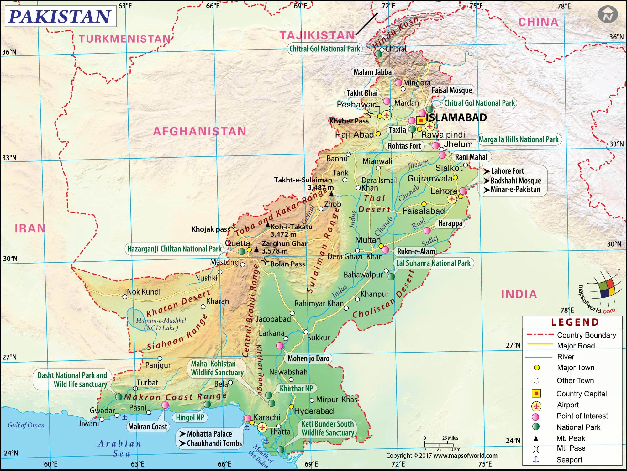
Pakistan belongs to the continent of Asia, specifically situated within the subregion of South Asia. Bordered by India to the east, Afghanistan and Iran to the west, China to the north, and the Arabian Sea to the south, its physical coordinates place it firmly at a historic geopolitical crossroads. While continent classifications sound simple on paper, understanding Pakistan's exact regional placement requires looking at both physical landmass boundaries and cultural intersections.
Many people confuse country subregions with actual continents. Because Asia is the largest continent on Earth, it is subdivided into distinct geographic zones like East Asia, Southeast Asia, Central Asia, and South Asia. Pakistan's positioning in South Asia links it closely with its neighbors, yet its historical trade routes and ethnic overlaps also connect it tightly to Central Asia and the Middle East. Let's break down the exact geographical and cultural realities that define Pakistan's place on the map.
The Continental and Regional Breakdown
On a macro level, Asia houses 48 countries, and Pakistan is one of them. Geographers categorize the nation under the South Asia regional UN geoscheme. This region features distinct topographical and climatic features, separated from the rest of Asia by massive mountain ranges like the Himalayas, the Karakoram, and the Hindu Kush.
- Continent: Asia
- Subregion: South Asia
- Bordering Regions: Central Asia to the northwest, West Asia (Middle East) to the west.
- Coastline: The Arabian Sea to the south, providing direct access to Indian Ocean trade routes.
These boundaries aren't just lines on a map. They dictate climate patterns like the South Asian monsoon, tectonic plate boundaries (the Indian Plate colliding with the Eurasian Plate), and major river systems like the Indus River basin that sustain millions of residents.
Geographic Intersection Point
Pakistan doesn't just sit in South Asia; it acts as a bridge between multiple cultural and geographic realms. To understand its unique position, look at its borders and regional proximity:
- The Northern Heights: The rugged northern territories share borders with China's Xinjiang region, meeting through high-altitude mountain passes like the Khunjerab Pass.
- The Western Threshold: Moving westward, Pakistan shares porous and historic borders with Afghanistan and Iran, tying its security and trade dynamics to West Asia.
- The Eastern Neighbor: The long eastern border with India shares deep historical, linguistic, and ecological roots that date back centuries before modern borders were drawn.
This crossroads positioning means that while Pakistan is unequivocally Asian, its day-to-day trade, cultural exchanges, and political alignments span multiple spheres. For instance, infrastructure initiatives like the China-Pakistan Economic Corridor explicitly leverage this spot to link western China directly to warm-water ports on the Arabian Sea.
Common Misconceptions About Asian Subregions
People often mix up continents with regions or economic blocs. Clarifying these terms prevents common geography mix-ups:
- Confusing Middle East and South Asia: Because Pakistan shares strong religious, historical, and economic ties with Gulf nations, people occasionally mislabel it as part of the Middle East. Geographically, it sits outside the Middle East.
- Confusing Continent with Country Size: As the fifth-most populous country globally, Pakistan's massive population sometimes leads casual observers to think of it as a standalone region rather than part of the wider Asian landmass.
- The Central Asian overlap: Cultural traits in Pakistan's northern and western provinces share heavy commonalities with Central Asian nations, but the country's core administrative and population centers remain anchored in the Indus plains of South Asia.
Frequently Asked Questions
Is Pakistan part of the Middle East?
No. Pakistan is located in South Asia. While it shares close cultural, religious, and economic partnerships with Middle Eastern countries, its geographic home is South Asia.
What are the neighboring countries of Pakistan?
Pakistan shares land borders with four nations: India to the east, Afghanistan to the northwest, Iran to the west, and China to the north. It also shares a maritime border with Oman.
Why is Pakistan sometimes associated with Central Asia?
Historical trade routes, such as the ancient Silk Road, and ethnic overlaps in provinces like Khyber Pakhtunkhwa and Balochistan connect Pakistan closely to Central Asian cultures, even though its official regional designation is South Asia.
How big is Pakistan compared to other Asian countries?
Pakistan spans approximately 881,913 square kilometers, making it the 33rd largest nation globally and one of the largest by land area in South Asia.



