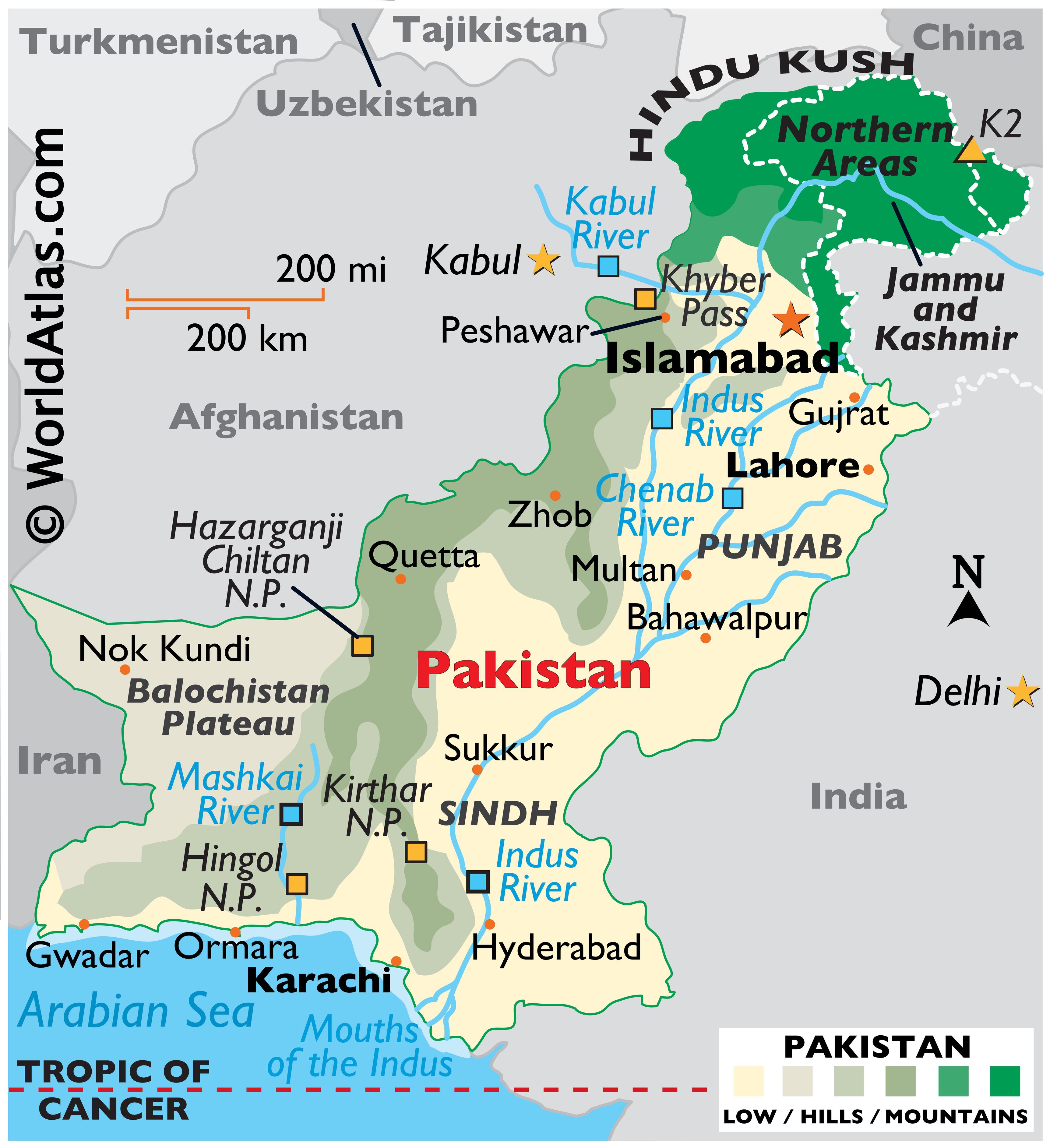
Pakistan occupies a critical geographic junction in South Asia, acting as a continental bridge linking South Asia, Central Asia, and the Middle East. Positioned on the western edge of the Indian subcontinent, the country spans an area of approximately 881,913 square kilometers, featuring a long coastline along the Arabian Sea to the south. Its absolute location sits roughly between coordinates 23.45°N to 36.75°N latitude and 60.87°E to 75.30°E longitude, shaping a territory characterized by stark topographical contrasts ranging from coastal plains to the highest mountain peaks on earth.
Understanding where Pakistan sits on the map requires examining its precise coordinates, immediate land neighbors, and the geostrategic trade corridors that cross through its provinces.
Exact Geographic Positioning Within Asia
Pakistan is officially categorized as a South Asian nation. However, its physical location places it at a unique crossroads where regional spheres bleed into one another:
- To the east and southeast lies the rest of the South Asian landmass, dominated by its major neighbor, India.
- To the northwest and west, the terrain transitions into the rugged plateaus and highlands of Central Asia and Western Asia.
- To the west, close proximity to Iran provides an immediate gateway to the Middle East.
- To the northeast, the country shares a direct frontier with East Asia via China.
This positioning places Pakistan outside the traditional borders of the Middle East, though historical, religious, and economic ties bind it closely to Persian Gulf states. Similarly, while it isn't part of Central Asia, landlocked former Soviet republics look to Pakistan's southern ports for the shortest access to global maritime trade routes.
International Land Borders and Neighbors
Pakistan shares its land boundaries with four primary nations, spanning a total borderline of roughly 7,307 kilometers. Each border carries a distinct historical framework and operational reality.
The Eastern Border: India
The boundary between Pakistan and India stretches for approximately 3,320 kilometers. Established in August 1947 through the Radcliffe Award, this frontier runs from the disputed region of Kashmir down to the marshy salt flats of the Rann of Kutch in Sindh. The most prominent crossing point is Wagah, situated on the historic Grand Trunk Road between Lahore and Amritsar, famous for its daily military flag-lowering ceremony.
The Western Border: Afghanistan
Pakistan's western and northwestern frontier meets Afghanistan along a 2,640-kilometer line known as the Durand Line. Demarcated in 1893 during the British colonial era, this boundary cuts across mountainous terrain and historically autonomous tribal territories. Near its northernmost tip, the narrow Afghan Wakhan Corridor separates Pakistan from Tajikistan by a matter of kilometers, preventing a direct border with Central Asia.
The Southwestern Border: Iran
To the southwest, Pakistan shares a 959-kilometer border with Iran, stretching from direct desert terrain down to the Gwadar coastal region. This frontier connects Pakistan's Balochistan province with Iran's Sistan and Baluchestan province. Trade, energy sharing, and cross-border security management define the modern dynamics of this boundary.
The Northeastern Border: China
In the far northeast, nestled high in the Karakoram mountains, Pakistan meets China along a 559-kilometer border. Formalized through the Sino-Pakistan Agreement of 1963, this high-altitude frontier includes the Khunjerab Pass, one of the highest paved international border crossings in the world, sitting over 4,600 meters above sea level. This border serves as the entry point for the China-Pakistan Economic Corridor (CPEC), a multi-billion dollar network of highways and energy pipelines.
Maritime Boundaries and Southern Access
While land borders define three sides of Pakistan, the southern boundary is entirely maritime. The country commands a coastline of roughly 1,046 kilometers along the Arabian Sea and the Gulf of Oman.
This coastline gives Pakistan an Exclusive Economic Zone (EEZ) spanning approximately 290,000 square kilometers. Major ports like Karachi and the deep-water port of Gwadar in Balochistan anchor this maritime frontage. Gwadar, in particular, sits near the mouth of the Persian Gulf, giving it immediate proximity to global oil shipping lanes and positioning it as a transshipment hub for goods moving between maritime routes and landlocked Asian economies.
Topography and Regional Division
Pakistan's internal geography is divided into distinct structural zones that dictate climate, population density, and economic activity:
- The Northern Highlands: Dominated by the Karakoram, Hindu Kush, and Himalayan mountain ranges, this region contains the world's second-highest peak, K2, along with massive glaciers that feed the country's river systems.
- The Indus Plain: Formed by the alluvial deposits of the Indus River and its major tributaries (such as the Chenab, Jhelum, and Sutlej), this fertile basin spans Punjab and Sindh, serving as the agricultural heartland.
- The Balochistan Plateau: Covering the western half of the country, this arid, sparsely populated region features dry mountain basins, mineral deposits, and pastoral grazing lands.
- The Desert Regions: The Thar Desert spans the southeastern border with India, while the Cholistan Desert sits in eastern Punjab, characterized by sand dunes and extreme seasonal temperatures.
Frequently Asked Questions
Is Pakistan part of the Middle East?
Geographically, no. Pakistan is located in South Asia. However, cultural, religious, and economic ties with the Persian Gulf nations often result in close diplomatic alignment with the Middle East.
What is the highest point in Pakistan?
The highest point is K2, which reaches 8,611 meters above sea level. Located in the Karakoram range on the border with China, it is the second-tallest mountain on Earth.
Does Pakistan share a border with Tajikistan?
No, Pakistan and Tajikistan do not share a direct border. They are separated by a narrow strip of Afghan territory known as the Wakhan Corridor, which extends eastward to the Chinese border.
What is the primary river system in Pakistan?
The Indus River is the country's longest and most vital waterway. Originating on the Tibetan Plateau, it flows the entire length of Pakistan before emptying into the Arabian Sea, sustaining the country's vast irrigation network.



