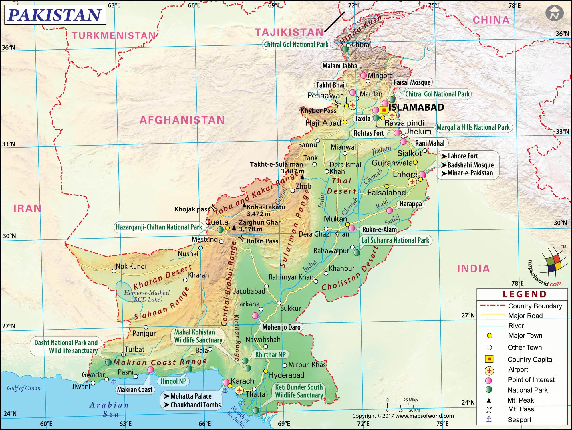
Pakistan is located on the continent of Asia, specifically within the subregion of South Asia. If you look at a global map, it sits at a critical geopolitical crossroads where South Asia meets Central Asia and the Middle East.
Understanding its precise continental placement requires looking beyond basic maps. Regional definitions mix physical landmasses, cultural ties, and geopolitical agreements. Let's break down the physical and regional realities that define Pakistan's place on the map.
The Continental Foundation: Asia
At the broadest level, Pakistan is part of Asia, the largest and most populous continent on Earth. This landmass stretches from the Mediterranean Sea to the Pacific Ocean. Within this vast continent, countries are grouped into distinct subregions based on shared physical features, history, and cultural traits.
Pakistan's official continental designation places it firmly in Asia, but international organizations and geographers narrow this down further. According to the United Nations geoscheme for Asia, Pakistan belongs to the statistical region of South Asia, sharing this categorization with neighbors like India, Bangladesh, and Nepal.
Why Pakistan Belongs to South Asia
Geographic subregions aren't random lines drawn on a chalkboard. They reflect shared topography, climate systems, and historical connections.
- The Indian Tectonic Plate: Geologically, Pakistan sits primarily on the Indian Plate. This tectonic plate collided with the Eurasian Plate millions of years ago, creating the towering mountain ranges that define the region today.
- The Indus River Basin: The lifeblood of the country is the Indus River system, which drains from the Himalayas and flows through the entire length of the country into the Arabian Sea. This river basin ties Pakistan ecologically to the wider South Asian plains.
- Monsoon Climate: Much of the country experiences a tropical to subtropical monsoon climate, heavily influenced by the seasonal weather patterns that drive South Asian agriculture.
Neighboring Regions and Overlaps
Because of its unique location, Pakistan bridges multiple cultural and geographic spheres. It shares long borders with four nations, each pulling its identity toward a different adjacent region:
- India to the East: Reinforces its core South Asian identity through shared history, linguistic roots, and cultural traditions.
- Afghanistan and Iran to the West: Connects Pakistan to Central Asia and Western Asia, creating deep ethnic and historical overlaps with the Middle East and the Afghan plateau.
- China to the Northeast: Links the country directly to East Asia through the high Karakoram mountains and major infrastructure corridors like the China-Pakistan Economic Corridor.
These cross-cutting borders mean that while Pakistan is geographically and statistically South Asian, it functions as a strategic pivot point between three major regional worlds.
Common Misconceptions About Pakistan's Location
People often confuse political alliances or religious demographics with strict continental geography. Clearing up these confusions makes the map much easier to read.
Is Pakistan Part of the Middle East?
No. While Pakistan has close religious and diplomatic ties with many Middle Eastern nations—and a large expatriate workforce living in the Gulf states—it is not part of Western Asia or the Middle East. Its geographic bedrock, river systems, and indigenous cultures are rooted entirely in South Asia.
Is It Part of Central Asia?
While historical trade routes like the Khyber Pass have linked Pakistan to Central Asia for centuries, the country itself is not located in Central Asia. The Hindu Kush and Pamir mountain ranges form a rugged natural barrier separating Pakistan from landlocked Central Asian states like Tajikistan and Uzbekistan.
Frequently Asked Questions
What languages are spoken in Pakistan?
Urdu is the national language, and English serves as the official language for government and corporate use. Regionally, Punjabi, Pashto, Sindhi, and Balochi are spoken by millions across different provinces.
How big is Pakistan compared to other South Asian nations?
Pakistan is the second-largest country in South Asia by land area, trailing only India. It spans roughly 881,913 square kilometers.
Why is the region called South Asia instead of the Indian Subcontinent?
While "Indian Subcontinent" is an older historical and geological term describing the physical landmass south of the Himalayas, "South Asia" is the modern political and geographic term used by international bodies to encompass all nations in the area without political naming friction.



