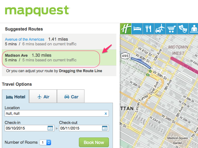
Long before smartphones tracked our exact coordinates in real-time, getting from one city to another required a trip to a family computer, a dial-up internet connection, and a desktop printer. MapQuest driving directions defined an entire era of travel. Launched in 1996, it turned static road atlases into digital routing instructions, establishing the foundational blueprint for how we navigate physical space today.
While modern smartphones offer dynamic, turn-by-turn voice commands that adjust on the fly, the architecture of digital routing built during the late 1990s laid the structural groundwork for modern algorithms. Understanding how early web mapping operated reveals how a simple text-based query transformed global transit.
The Birth of Digital Cartography
The roots of digital route planning stretch back further than most realize. Long before the domain name was registered, the underlying engine grew out of Cartographic Services, a division established by R.R. Donnelley & Sons in 1967. This division originally produced the paper road maps handed out for free at gas stations across the United States.
By the mid-1980s, the company began digitizing geographic data. When GeoSystems spun off and launched MapQuest in 1996, it combined spatial databases with early web technology. Users could type in a start address and a destination, and the server would compute a vector-based route, rendering static images and text-based step-by-step instructions.
[User Input: Start & End Addresses]
       ↓
[Geocoding Engine: Matching text to coordinates]
       ↓
[Routing Algorithm: Calculating shortest path via graph theory]
       ↓
[Output: Sequential text directions & static map image]
This sequence solved a massive logistical hurdle for everyday travelers. Instead of tracing routes across massive folded paper maps, drivers received a customized text checklist that broke down every highway transition and street name.
Anatomy of Printed Route Instructions
The user experience of early digital navigation relied on physical paper. Travelers printed their routes before leaving home, often using color ink jets to make the maps legible.
A standard printout included several distinct elements:
- Total Mileage and Estimated Time: Calculated based on static speed limits assigned to specific road segments.
- Sequential Turn-by-Turn Steps: Numbered lists specifying distances, cardinal directions, and street names (for example, "Turn right on Oak Street and drive for 1.4 miles").
- Static Map Snippets: Small, unpannable graphical crops of complex interchanges or destination areas.
This static nature created a specific set of challenges. If a driver missed a turn or encountered unexpected construction, the pre-printed instructions became instantly obsolete. Recovering required pulling over, finding a gas station, and unfolding a backup paper atlas.
The Algorithmic Engine Behind the Maps
At its core, route calculation relies on graph theory. Road networks are modeled as mathematical graphs where intersections act as vertices (nodes) and road segments act as edges. Each edge carries a weight representing distance, travel time, or speed limit.
To find the fastest or shortest path, mapping platforms deployed variations of pathfinding algorithms like Dijkstra's algorithm or the A* search algorithm.
- Graph Representation: Major highways and local streets were digitized into millions of interconnected data points.
- Heuristic Optimization: Because searching an entire national grid for every query would crash early servers, engineers used heuristic pruning to rule out illogical directions early in the calculation process.
- Static Weighting: Unlike today's dynamic systems that ingest live traffic data from millions of active mobile devices, early algorithms relied on fixed variables—primarily distance and posted speed limits—assuming free-flow traffic conditions at all times.
Transition to the Modern Era of Algorithms
As broadband internet expanded and mobile smartphones entered the consumer market in the late 2000s, user expectations shifted rapidly. Static web mapping faced intense competition from dynamic, tile-based interfaces and GPS-enabled hardware.
The transition from static text lists to real-time navigation involved three major shifts:
- Tile-Based Rendering: Moving away from single, slow-loading static images to dynamic, pannable map tiles that loaded asynchronously.
- Crowdsourced and Live Telemetry: Integrating real-time speed data from connected vehicles to detect congestion and automatically reroute drivers around accidents.
- Hardware Integration: Shifting computation from desktop browsers to pocket-sized mobile sensors equipped with dedicated GPS chips.
Despite these changes, the core computational challenge—determining the most efficient path through a complex web of streets—remains rooted in the foundational logic established during the early web mapping era.
Frequently Asked Questions
When was MapQuest launched?
MapQuest launched publicly in 1996, making it the first widely available commercial web-based mapping service.
How did early web mapping calculate routes without GPS?
Early platforms relied on geocoding—matching text-based street addresses to geographic coordinate databases—and applied graph theory algorithms to calculate distances along digitized road segments.
Why did printed directions often fail drivers?
Because the instructions were calculated statically before a trip began, any unexpected road closure, construction zone, or missed turn rendered the remaining paper steps inaccurate, requiring manual rerouting.
Does MapQuest still exist today?
Yes. While it lost market share to smartphone-native applications, it continues to operate as an online routing and mapping platform.