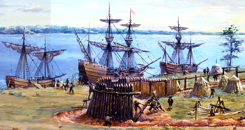
Jamestown, Virginia sits on the north bank of the James River in James City County, roughly five miles southwest of modern Williamsburg. When 104 English colonists stepped ashore on May 14, 1607, they didn't pick a random patch of dirt; they chose a specific peninsula designed for military defense and maritime access. Today, natural erosion and rising tides have turned the site into an island, but its original geographic layout shaped the survival, struggles, and ultimate success of America's first permanent English settlement.
Understanding Jamestown requires looking past romanticized stories and examining actual cartography, river currents, and tactical positioning.
The 1607 Geographic Selection
The Virginia Company of London gave strict orders regarding how settlers should choose a location for their fortified outpost. Geography dictated every single rule.
- Deep-Water Anchorage: The channel right next to the shore was deep enough for ocean-going ships like the Susan Constant, Godspeed, and Discovery to tie directly to the trees. Settlers didn't need a built-out pier to unload cargo.
- Inland Protection: Situated roughly 40 miles upstream from the Chesapeake Bay, the site was far enough inland to shield the early pioneers from sudden naval raids by European rivals, particularly the Spanish.
- Three-Sided Water Barrier: In 1607, the location was a peninsula connected to the mainland by a narrow neck of land, bordered on three sides by the James River. This limited the land vectors an enemy force could use to mount an attack.
+---------------------------------------------------+
|               The Original Jamestown Layout       |
|                                                   |
|       [James River] <--- Water Boundary           |
|            |                                      |
|            +--- Triangular James Fort             |
|            |    (Built low near the shoreline)    |
|       [James River] <--- Water Boundary           |
|                                                   |
|       Narrow Neck of Land (Connected to Mainland) |
+---------------------------------------------------+
Mapping the Strategic Environment
The physical environment handed the colonists severe tactical advantages alongside hidden, lethal disadvantages. While military planners in London loved the peninsula layout for its defensibility, natural scientists recognize that the spot was ecologically precarious. For another angle on this story, see the recent update from Reuters.
Low Elevation and Water Access
Most of Jamestown Island sits barely above sea level. The terrain is a mix of low ridges, swamps, and tidal marshes. In 1607, this meant the settlers were camping on a mosquito-infested wetland. The brackish water of the James River—shifted by coastal tides—created a stagnant drinking supply during dry summer months when salt water crept up the river channel.
Proximity to Indigenous Populations
The geographic choice put the English right inside the expansive Powhatan Chiefdom. Chief Powhatan controlled a network of tribes across the Tidewater region. While the English thought their isolated peninsula kept them safe from native attack, it also put them at the center of a complex geopolitical web. They were squatting on land that local tribes used for hunting, fishing, and diplomacy.
Read more about the preservation efforts at the National Park Service Historic Jamestowne page.
Evolution from Peninsula to Island
Over four centuries, natural forces radically altered the map. The narrow land bridge connecting the peninsula to the mainland eroded away, turning Jamestown into a true island separated by the Back River and the Thorofare.
Coastal erosion has eaten away portions of the original 1607 James Fort site. Archaeologists from the Historic Jamestowne Rediscovery Project have spent decades recovering artifacts before the James River reclaims them permanently. Rising sea levels and changing tidal patterns continue to threaten the fragile shoreline, prompting modern engineers to install complex breakwaters and rock revetments to protect what is left of the historic heartland.
Common Misconceptions About Jamestown's Geography
- Myth: Jamestown was always an island. Reality: It was a peninsula in 1607; centuries of erosion and rising water converted it into an island.
- Myth: The settlers picked a lush, fertile garden spot. Reality: They chose a swampy, isolated military choke point designed to fend off Spanish warships, which contributed heavily to the high mortality rates during the early years.
- Myth: Jamestown remained the capital of Virginia indefinitely. Reality: After a major fire in 1698, the government relocated inland to Middle Plantation, which was renamed Williamsburg, leaving Jamestown to fade into farmland.
Frequently Asked Questions
Why did the Jamestown settlers choose such a swampy location?
They prioritized military defense over comfort. The Virginia Company demanded a site that was easy to fortify against Spanish attack and deep enough for ships to dock safely. Swampy wetlands seemed a small price to pay for security against foreign navies.
How do I get to Historic Jamestowne today?
Visitors can access the site via the scenic Colonial Parkway from Williamsburg. The area connects directly to the Historic Triangle, which also includes Yorktown and Williamsburg.
Is anything left of the original 1607 fort?
Parts of the original fort survived underground despite popular belief that the entire structure washed into the river. Modern archaeological excavations have uncovered thousands of structural postholes, armor pieces, and personal items.
What role did geography play in Jamestown's economic shift?
Once John Rolfe introduced sweet-leaf tobacco, the geography of the entire region changed. Settlers abandoned tight clustering around the original fort and spread out along the riverbanks into massive land patents called "hundreds" to maximize crop yields.



