Navigating the coastal waters and tidal rivers around Jacksonville requires a firm grasp of local marine weather dynamics, which shift rapidly between the Atlantic Ocean, the Intracoastal Waterway, and the mouth of the St. Johns River. Tidal currents can turn deceptively strong near the jetties, while afternoon sea breezes frequently catch unprepared boaters off guard with choppy swells and sudden squalls.
Understanding these conditions prevents groundings, engine strain, and dangerous situations on the water. Whether you're heading offshore past Mayport or cruising upriver toward downtown, knowing how to interpret forecasts, tide tables, and local geographic hazards is essential for a safe day on the water.
Decoding Jacksonville's Tidal Dynamics
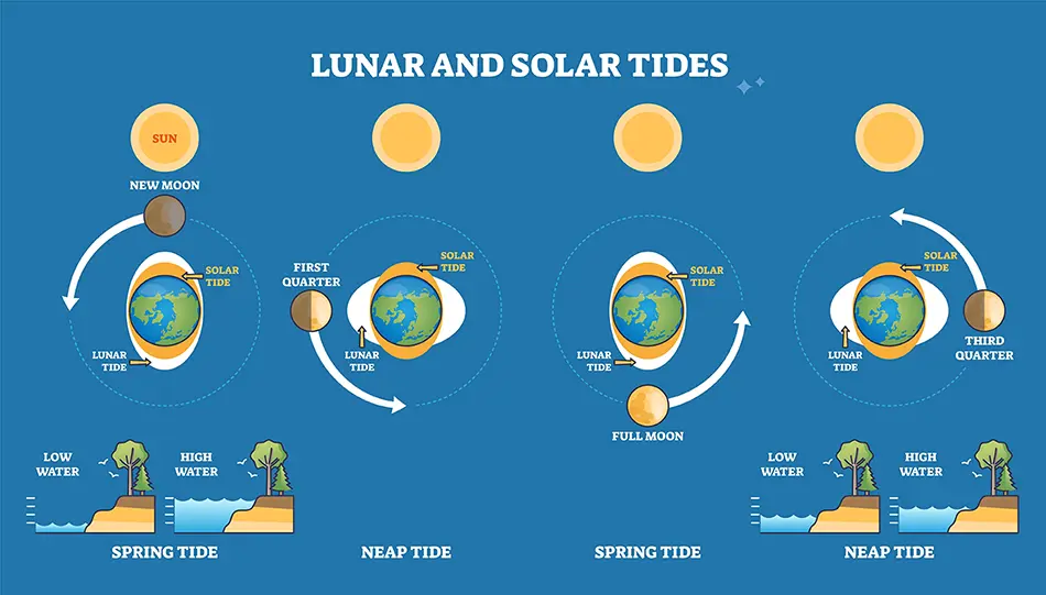
Tides in Northeast Florida follow a semi-diurnal pattern, meaning there are two high tides and two low tides roughly every 24 hours. However, the open ocean tide tables don't tell the whole story once you transition from Jacksonville Beach into the inland waterways.
St. Johns River Inlets and Current Spikes
The St. Johns River meets the Atlantic Ocean at the Mayport jetties, creating a notorious bottleneck. When an outgoing ebb tide collides with strong onshore east winds, standing waves and steep, breaking seas form quickly between the jetties.
- Flood Tides: Push saltwater westward into the river, aiding upstream travel but creating opposing currents if you're trying to anchor or dock facing east.
- Ebb Tides: Rush outward toward the ocean at speeds often exceeding 2 to 3 knots, stacking against ocean swells.
- Slack Water: Occurs briefly between tidal shifts, offering the calmest window for passing through the narrow jetty entrance.
Intracoastal Waterway Variations
Inside the Intracoastal Waterway, tidal flow timing shifts depending on how far water has to travel through narrow creeks and marshes. High tide at a marina on the Pablo Creek or the Ortega River can lag behind the ocean high tide by an hour or more. Always check secondary tide stations specific to your exact cruising zone rather than relying solely on coastal beach numbers.
Reading Local Marine Forecasts
The National Weather Service office in Jacksonville covers marine zones extending from Fernandina Beach down to Flagler Beach, split into nearshore coastal waters and offshore waters. Interpreting these bulletins correctly keeps your vessel out of trouble.
Small Craft Advisories vs. Exercise Caution
When reviewing forecasts from the National Weather Service, pay close attention to advisory triggers:
- Small Craft Exercise Caution (SY): Usually issued when sustained winds reach 15 to 20 knots or seas build to 4 to 6 feet, creating choppy conditions that demand extra vigilance in smaller boats.
- Small Craft Advisory (SC): Signifies sustained winds of 20 to 25 knots or hazardous wave heights exceeding 6 to 7 feet. If you operate a boat under 26 feet, staying at the dock is often the smartest choice.
Sea Breezes and Afternoon Thunderstorms
During spring and summer months, the collision of the Atlantic sea breeze and the Gulf Coast sea breeze over the Florida peninsula triggers severe afternoon thunderstorms. These storms pack localized wind gusts over 40 knots, dangerous cloud-to-water lightning, and torrential downpours that reduce visibility to near zero within minutes. Monitoring live radar before heading out across open stretches of the river is non-negotiable.
Practical Steps for Safe Coastal Navigation
Preparation minimizes risk when confronting unpredictable marine conditions in Northeast Florida. Use a systematic checklist before untying your lines.
- Check Multiple Sources: Compare official NOAA marine zone forecasts with real-time wind sensor data from coastal buoys and the Florida Oceanographic Society monitoring networks.
- Plan Around the Jetties: If you plan to head offshore, time your departure or return to avoid crossing the St. Johns River entrance during an outgoing ebb tide combined with an east wind.
- Inspect Safety Gear: Ensure your life jackets, marine radio, visual distress signals, and anchor tackle are fully operational before entering high-current areas.
- Monitor VHF Weather Channels: Keep your marine radio tuned to continuous weather broadcasts on channels WX1 through WX7 to catch sudden warning updates.
Common Mistakes to Avoid
Even experienced captains occasionally fall victim to local oversight in Jacksonville waters. Avoiding these common errors ensures a safer trip.
- Underestimating River Current: Assuming the St. Johns River flows calmly at all times is a mistake. Strong currents can sweep a drifting boat into bridge pilings or docks if your engine fails.
- Ignoring Shoaling Near Inlets: Shifting sandbars near the St. Johns River entrance and smaller cuts mean water depths change frequently. Always adhere strictly to posted channel markers rather than cutting corners.
- Relying Solely on Smartphone Apps: Generic weather apps often lack granular marine data for wind fetch, wave periods, and tidal vectors. Stick to dedicated marine forecasting tools.
Frequently Asked Questions
How fast do tidal currents run through the St. Johns River jetties?
Max currents in the inlet frequently reach 2 to 3 knots, and can run even higher during extreme spring tides or heavy freshwater runoff events following major inland rainfall.
Why is the water so choppy near Mayport even on calm days?
When ocean swells meet outgoing tidal currents flowing out of the river mouth, opposing forces steepen the wave action, creating short-period chop right at the inlet.
How far up the St. Johns River do ocean tides reach?
Tidal influence extends remarkably far inland, past downtown Jacksonville and all the way toward the Shands Bridge and parts of Lake George, though the actual water level fluctuation diminishes significantly the further south you go.
What is the safest time of day to cross the bar at Jacksonville?
Morning hours typically offer the calmest conditions before the daytime sea breeze builds and afternoon convective thunderstorms begin to form over the coastal shelf.