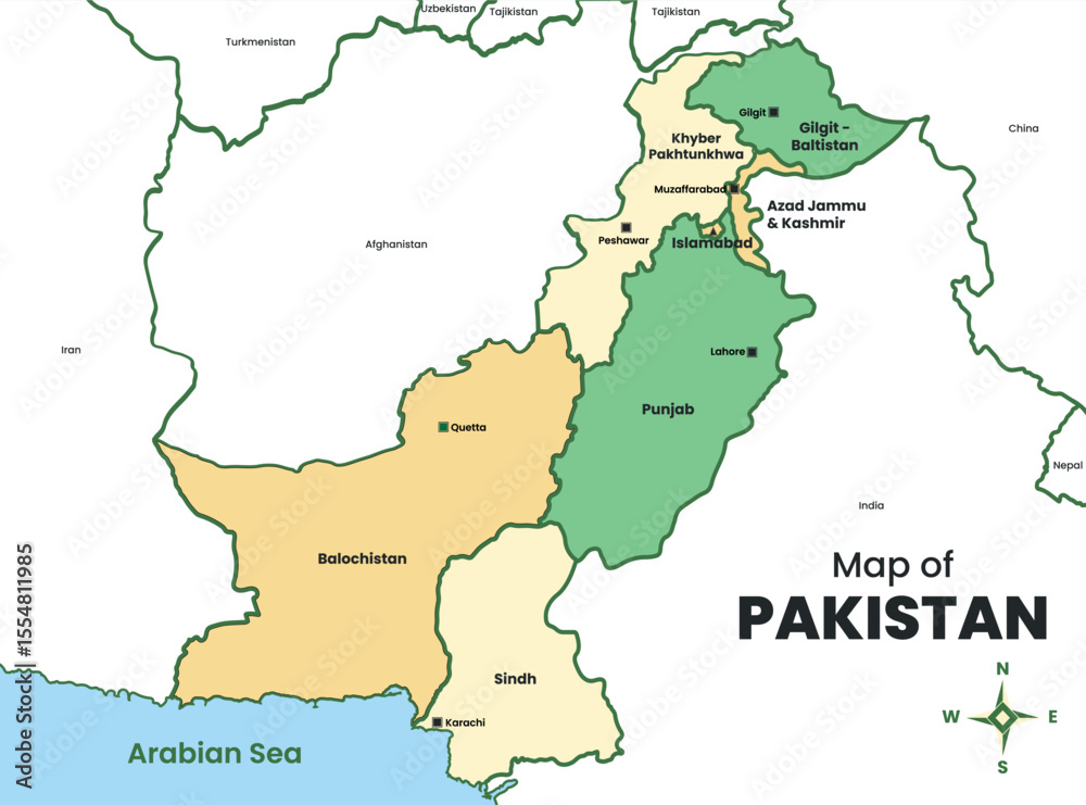
Yes, Pakistan is firmly in Asia. Specifically, it occupies a vital strategic position in South Asia, bordered by the Arabian Sea to the south, India to the east, Iran and Afghanistan to the west, and China to the north. Spanning over 880,000 square kilometers, the country acts as a physical and cultural bridge connecting South Asia with Central Asia and the Middle East.
Understanding where Pakistan sits on the map requires looking beyond a simple continental label. Its landscape transitions from coastal plains and fertile river basins to some of the highest mountain peaks on earth, shaping a distinct geopolitical and cultural identity that influences international trade, migration, and regional politics.
The Physical Geography of Pakistan
Pakistan's terrain is intensely diverse, split naturally by the towering mountain ranges and the massive drainage basin of the Indus River.
- The Northern Heights: The Himalayas, Karakoram, and Hindu Kush ranges converge in northern Pakistan. This region hosts K2, the world's second-highest peak, creating a rugged natural barrier between South Asia and Central Asia.
- The Indus River Basin: Often called the lifeline of the country, the Indus River system flows from the Tibetan Plateau down to the Arabian Sea. It feeds the Punjab and Sindh plains, forming one of the most heavily irrigated agricultural zones in the world.
- The Western Plateaus: Moving westward toward Iran and Afghanistan, the terrain shifts into the arid Balochistan plateau, characterized by dry mountain ranges and desert basins.
- Southern Coastline: The Arabian Sea coastline spans over 1,000 kilometers, featuring major commercial ports like Karachi and Gwadar that link landlocked Central Asian nations to global shipping lanes.
Regional Classification and International Frameworks
Global institutions classify Pakistan within specific regional blocks based on shared environmental, historical, and economic traits.
The United Nations Statistics Division places Pakistan squarely in Southern Asia, alongside India, Bangladesh, Nepal, Sri Lanka, Bhutan, and the Maldives. This grouping reflects shared monsoon climate systems, historical trade patterns, and demographic ties.
At the same time, Pakistan maintains deep ties with western neighbors. Its northern and western provinces share linguistic and tribal characteristics with Central Asian and Middle Eastern populations. This overlap explains why international organizations and defense analysts frequently view Pakistan as a cross-regional pivot point.
Cultural and Historical Context
Geography tells only half the story. Pakistan's culture reflects centuries of convergence between various civilizations, including Persian, Turkic, Arabic, and indigenous South Asian influences.
- Linguistic Diversity: While Urdu is the national language, regional languages like Punjabi, Pashto, Sindhi, Balochi, and Saraiki dominate daily life, mirroring historical migration routes and ethnic distributions.
- Architectural Heritage: Remnants of the ancient Indus Valley Civilization—such as Mohenjo-daro and Harappa—sit alongside magnificent Mughal-era structures like the Badshahi Mosque and Lahore Fort, tying the nation firmly to South Asian historical milestones.
- Religious Demographics: Pakistan is home to the second-largest Muslim population globally, heavily shaping its social fabric, festivals, and legal framework, which operates as an Islamic republic.
For deeper reading on global regional mapping standards, check the United Nations Statistics Division methodology. To examine international trade and diplomatic frameworks in the region, review resources provided by the Government of Pakistan.
Common Misconceptions About Pakistan's Location
Because regional boundaries often overlap, travelers and students frequently encounter confusion regarding Pakistan's continental and regional standing.
Some confuse South Asia with the Middle East due to religious and historical trade connections with Gulf nations. Others mistake its rugged western frontier for part of the Middle Eastern desert belt. However, climatically and structurally, Pakistan relies heavily on the South Asian monsoon system and shares an immediate tectonic plate—the Indian Plate—with its eastern neighbors.
Frequently Asked Questions
Is Pakistan part of the Middle East?
No. While Pakistan shares close cultural, religious, and economic ties with Middle Eastern countries, it is geographically and politically part of South Asia.
Does Pakistan share a border with China?
Yes. Pakistan shares a high-altitude border in the north along the Karakoram range, connected via the historic Karakoram Highway, which cuts through the Khunjerab Pass.
Why is Pakistan sometimes associated with Central Asia?
Its western provinces border Afghanistan and Iran, and historical trade routes like the Silk Road deeply intertwined northern and western Pakistan with Central Asian cultures and empires.
What is the capital of Pakistan?
The capital is Islamabad, located in the federal capital territory near the foothills of the Margalla Hills in northern Pakistan, adjacent to the twin city of Rawalpindi.



