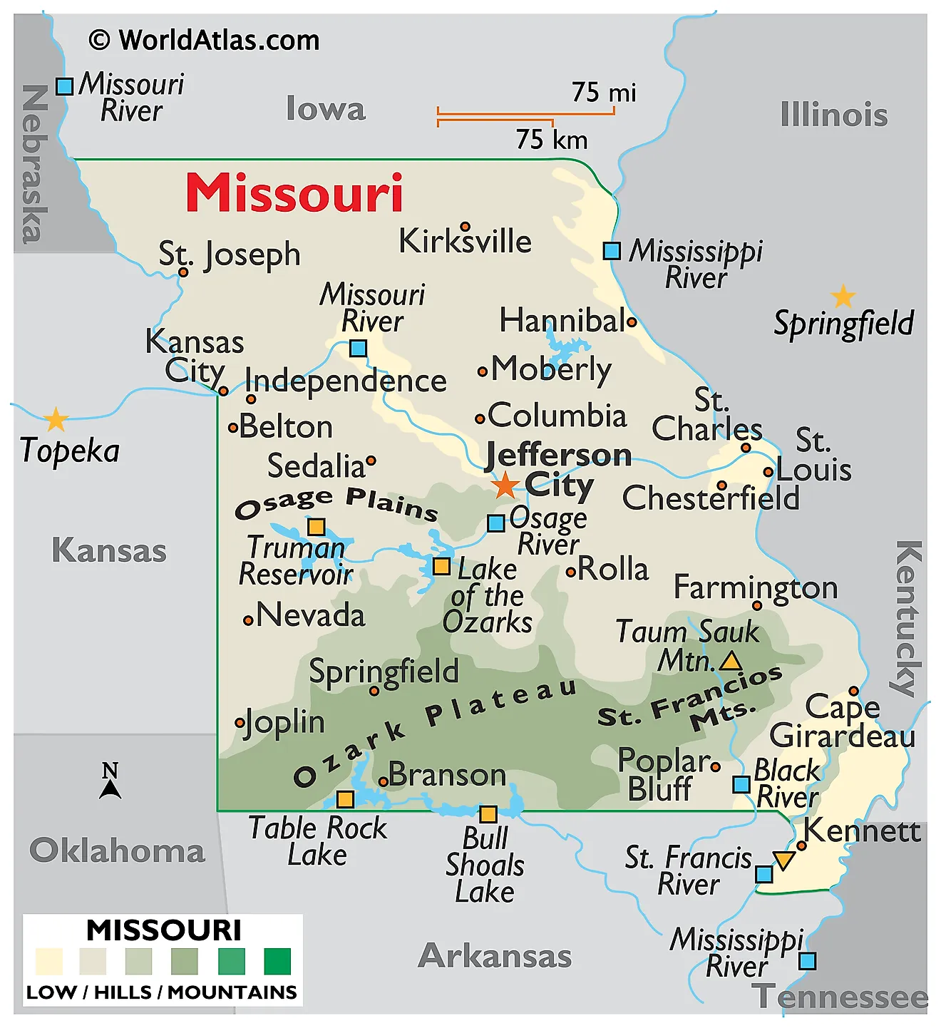
Yes, Missouri is a fully recognized state of the United States. Admitted to the Union on August 10, 1821, it became the 24th U.S. state. Located in the Midwestern region of the country, it functions as a distinct sovereign state with its own state government, constitution, and representation in the U.S. Congress, just like all other 50 states.
Despite occasional confusion caused by its geographic position near the center of the country and its name being shared with a major river and a historical territory, Missouri's status as a state is absolute. It spans roughly 69,700 square miles, houses a population of over six million people, and plays a foundational role in the economic, political, and cultural infrastructure of the nation.
The Path to Statehood: How Missouri Entered the Union
Missouri's journey to becoming a state wasn't simple. It started with the Louisiana Purchase of 1803, when the United States acquired vast territories west of the Mississippi River from France. By 1818, the population within the Missouri Territory had grown enough to apply for admission as a state.
This application sparked a national crisis over slavery. At the time, the U.S. Senate was evenly divided between free states and slave states. Admitting Missouri would disrupt this balance. Congress debated the issue for two years, ultimately passing the Missouri Compromise in 1820.
- The Compromise Terms: Missouri was admitted as a slave state, while Maine entered as a free state to maintain the political balance.
- The Geographic Line: The agreement drew an imaginary line across the remaining Louisiana Territory at latitude 36°30' north, prohibiting slavery north of that boundary (except within Missouri itself).
- Official Entry: President James Monroe signed the proclamation on August 10, 1821, making Missouri the 24th state.
Geographic Profile and Borders
Missouri occupies a unique spot in the heart of the American continent. It is a landlocked state sharing its borders with eight different states—a record it ties with Tennessee for the most bordering states in the country.
To its north lies Iowa. To the east, the Mississippi River separates it from Illinois, Kentucky, and Tennessee. Arkansas borders it to the south, while Oklahoma, Kansas, and Nebraska frame its western edge.
The landscape varies drastically from north to south. Northern Missouri features flat plains and glacial prairies left behind by ancient ice sheets. Southern Missouri features the rugged, heavily forested Ozark Plateau, known for its deep caves, springs, and rolling hills. Bisecting the entire state is the Missouri River, the longest river in North America, which empties into the Mississippi just north of St. Louis.
Government, Capital, and Major Cities
As a U.S. state, Missouri operates under a republican form of government split into executive, legislative, and judicial branches.
- The Capital: Jefferson City serves as the seat of state government, housing the capitol building overlooking the Missouri River.
- Major Urban Centers: Kansas City and St. Louis anchor the state's two largest metropolitan areas, driving innovation, finance, and culture. Other notable hubs include Springfield, Columbia, and St. Joseph.
- Political Structure: The state is divided into 114 counties alongside the independent city of St. Louis, giving local governments significant authority over regional administration.
According to the U.S. Census Bureau, Missouri maintains steady population growth anchored by strong manufacturing, aerospace, healthcare, and agricultural sectors.
Common Misconceptions About Missouri
People occasionally question Missouri's status or identity due to a few common linguistic and historical mix-ups.
Is Missouri a Territory or a Country?
Some encounter old historical texts referencing the "Missouri Territory" and confuse it with modern status. The territory ceased to exist in 1821 when statehood was granted. It is a sub-national state within the federal republic of the United States, not an independent country.
Why Is It Called the "Show-Me State"?
The state's most famous nickname—The Show-Me State—stems from a reputation for practical skepticism. While the exact origin remains debated, it reflects a cultural ethos where residents prefer tangible proof over grand promises.
Does the Name Mean Anything Special?
The name originates from the Missouria, an indigenous Siouan-language tribe that once lived along the river. In their Algonquian-speaking neighbors' lexicon, the term translated roughly to "town of the large canoes" or people associated with dugout boats.
Frequently Asked Questions
When did Missouri officially become a U.S. state?
Missouri officially entered the Union on August 10, 1821, under the provisions of the Missouri Compromise, making it the 24th state.
What states border Missouri?
Missouri shares its borders with eight neighboring states: Iowa to the north, Illinois, Kentucky, and Tennessee to the east, Arkansas to the south, and Oklahoma, Kansas, and Nebraska to the west.
What is the capital city of Missouri?
Jefferson City is the capital of Missouri, located along the Missouri River in the central part of the state.
Is Missouri considered part of the Midwest or the South?
Missouri bridges both regions. Culturally and geographically, it blends Midwestern industrial and agricultural traits with Southern historical influences, earning it a unique identity in the American Heartland.



