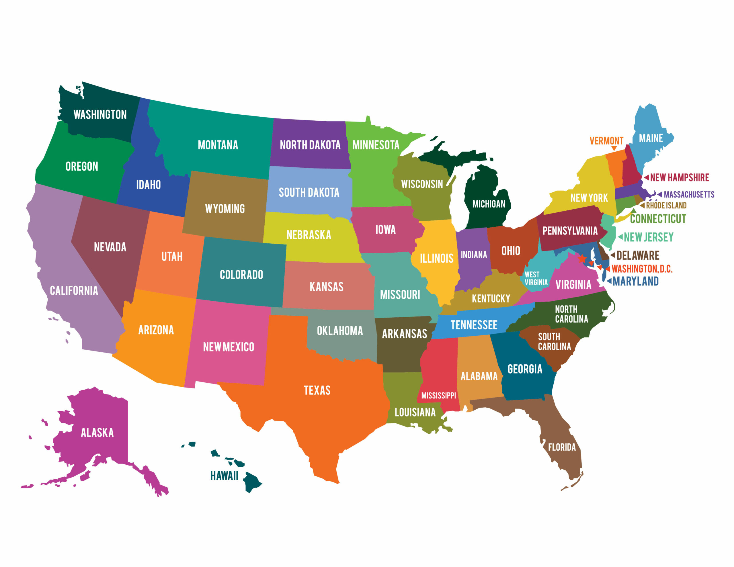
We look at a map of the United States and assume the borders are natural, like rivers or mountain ranges. But most state lines are the result of political compromises, surveying errors, slavery debates, and bitter land disputes. What look like random geometric shapes on a classroom poster actually tell the story of a country negotiating its own expansion.
The map of America wasn't drawn by divine intervention or pure geography. It was hammered out through colonial charters, royal decrees, local skirmishes, and congressional horse-trading. Understanding why states have jagged fingers, detached peninsulas, and straight-line western borders requires looking past the physical terrain and into the legislative history that carved them out.
Rivers, Ridges, and Royal Charters in the East
The original thirteen colonies didn't start with fixed western boundaries. Many royal charters granted land from the Atlantic Ocean "from sea to sea," creating massive overlapping claims that stretched across the continent. As independence took hold, states had to cede these western tracts to the federal government to keep the new union from fracturing.
Eastern and Midwestern borders relied heavily on navigable waterways because rivers served as the highways of early commerce.
- The Ohio River: Defined the border between multiple states, separating free territories from slave territories under the Northwest Ordinance.
- The Connecticut River: Created natural friction and split loyalties between New Hampshire and Vermont, which spent years operating as an independent republic before statehood.
- The Mason-Dixon Line: Surveyed by Charles Mason and Jeremiah Dixon between 1763 and 1767 to settle a boundary dispute between the Calvert family (Maryland) and the Penn family (Pennsylvania), later becoming the symbolic divide between North and South.
Relying on rivers created long-term headaches. Rivers change course over time through flooding and erosion, which led to decades of legal battles before the U.S. Supreme Court. When a river shifted, towns that thought they lived in one state suddenly found themselves across an administrative line.
The Slavery Debate and Western Panhandles
Politics and human bondage shaped some of the oddest protrusions on the map. The Missouri Compromise of 1820 prohibited slavery north of the 36°30′ parallel. This single legislative line warped geographic planning for decades.
Take the famous Oklahoma panhandle. When Texas sought admission to the Union in 1845 as a slave state, federal law prohibited slavery in territory north of that 36°30′ line. Because Texas leaders refused to give up their slaves to satisfy federal boundaries, they surrendered their claim to the strip north of that latitude. That strip sat unassigned for decades as "No Man's Land" before being attached to Oklahoma.
A similar political collision created West Virginia. When Virginia seceded in 1861, the western counties—largely mountainous, economically tied to the North, and dependent on small farms rather than plantations—refused to go along. They broke away, received congressional approval during the Civil War, and carved out a jagged eastern border that protected pro-Union sympathizers while leaving Confederate-leaning towns just across the line.
Surveyors, Latitudes, and the Grid System in the West
Once the nation pushed past the Mississippi River, rivers became too scarce to serve as reliable boundaries for the massive territories being carved out. Congress and surveyors turned to geometry.
The Land Ordinance of 1785 established a rectangular survey system that laid out the West in neat townships and sections. Surveyors walked across prairies and deserts with chains and compasses, setting lines of latitude and longitude.
- The 49th Parallel: Established by treaty with Great Britain, it created a straight-line international border from Minnesota to the Pacific Northwest, slicing right through geography regardless of local watersheds.
- Colorado and Wyoming: Perfect rectangles defined by degrees of latitude and longitude, engineered on paper in Washington D.C. long before permanent populations settled there.
This grid approach ignored indigenous territories, ecological regions, and water access. Settlers in arid western regions quickly realized that a straight line on a map didn't help a farm get water from a distant river.
Compromises, Ego, and Cartographic Accidents
Not every boundary came from grand legislation or grid systems; some resulted from stubborn politicians, mapping errors, and sheer luck.
The Toledo War
Michigan and Ohio nearly went to war in 1835 over a strip of land containing the vital port of Toledo. Congress stepped in with a compromise: Ohio got Toledo, and Michigan was compensated with the Upper Peninsula—a massive tract of land rich in timber and copper that wasn't connected to the rest of Michigan by land. At the time, residents thought Michigan got the raw deal, but the discovery of immense mineral wealth later made the Upper Peninsula a massive economic prize.
The Northwest Angle
A mapping error during the 1783 Treaty of Paris led to the creation of the Northwest Angle in Minnesota. Cartographers relied on a flawed map that placed the source of the Mississippi River too far north. Fixing the error left a tiny piece of U.S. territory completely cut off by water and Canada, accessible by land only by driving through Manitoba.
Frequently Asked Questions
Why is the Oklahoma panhandle so long and narrow?
It exists because Texas had to give up its claims to land north of the 36°30′ parallel to enter the Union as a slave state under the Missouri Compromise.
Why does Michigan have an Upper Peninsula?
Michigan received the Upper Peninsula as compensation from Congress after losing the Toledo War to Ohio in 1835.
Why are western states shaped like rectangles?
Surveyors used lines of latitude and longitude to divide western territories efficiently through the rectangular survey system once settlers moved past major river networks in the East.
Are state borders permanent?
Most borders are fixed by interstate compacts or Supreme Court rulings, but minor adjustments still happen when rivers shift or historical markers are re-surveyed.



