We used to treat geography as a fixed contract. Coastlines, mountain glaciers, and agricultural belts felt permanent, mapped into school atlases for generations. But rising global temperatures are rewriting those physical boundaries in real time, shifting ecological zones, melting permafrost, and forcing millions of species and human communities to relocate. This planetary transformation goes far beyond isolated weather anomalies; it physically alters the shape, utility, and borders of nations.
Understanding how environmental shifts reshape our globe requires looking past simple temperature anomalies to observe structural changes across ecosystems and infrastructure. From expanding deserts to drowned coastal cities, the physical lines dividing habitable land from wilderness are moving. We are watching the slow-motion redrawing of planetary geography, driven by cumulative carbon emissions and thermal expansion.
The Shrinking Cryosphere and Rising Oceans
The most visible cartographic changes happen at the poles and high-altitude mountain ranges. Glaciers and ice sheets store massive volumes of freshwater. As they melt, that water flows into the oceans, raising global sea levels and chewing away at shorelines.
Sea level rise isn't uniform. Gravitational effects, ocean currents, and local land subsidence mean some coastal regions experience water level increases significantly higher than the global average. Low-lying island nations like the Maldives face existential threats of total submergence, while major delta regions in Bangladesh and Southeast Asia lose productive agricultural land to saltwater intrusion.
Farmers in these coastal transition zones face a harsh reality: groundwater tables turn brackish, killing traditional crops long before the tide physically covers the fields. Governments spend billions on physical barriers, yet sea walls only buy time against an unrelenting thermodynamic process.
- Ice Sheet Acceleration: Greenland and Antarctic ice losses outpace historical models, injecting gigatons of water into the sea annualy.
- Thermal Expansion: As ocean waters warm, molecules expand, compounding the volume issues caused by melting land ice.
- Coastal Erosion: Storm surges reach further inland, permanently converting former wetlands and forests into open marine environments.
Shifting Climate Zones and Agricultural Boundaries
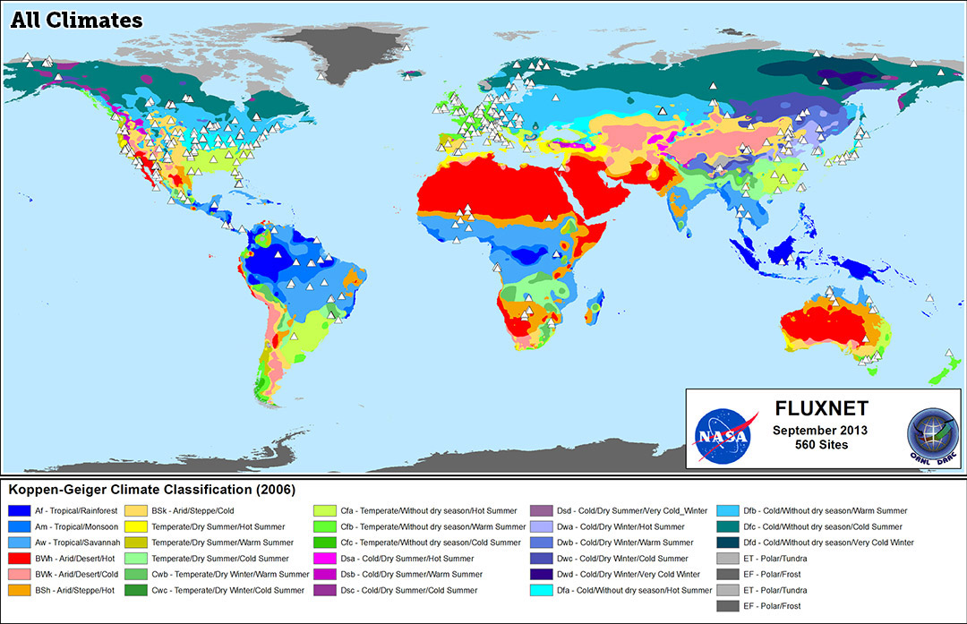
It isn't just the water's edge that's moving. Climate zones themselves are migrating toward the poles and up mountain slopes. The tropics are expanding by roughly half a degree of latitude per decade, pushing arid conditions into regions that were once reliably temperate.
In North America, the historic boundary between the arid West and the wetter East—long tracked near the 100th meridian—has shifted eastward by over a hundred miles. This movement forces dryland farming practices into regions previously dependent on natural rainfall. Similarly, plant hardiness zones across North America and Europe have marched steadily northward, altering pest ranges, forest health, and crop viability.
Traditional wine-growing regions in southern Europe struggle with excessive heat and erratic rainfall, prompting vintners to experiment with higher-elevation plots or cooler northern latitudes. Meanwhile, wheat belts in Australia and parts of the American Midwest face chronic yield contractions as historic precipitation patterns dissolve.
"Geography is no longer a fixed parameter. Climate change acts as a catalyst, defying human-drawn borders and altering the fundamental carrying capacity of landscapes."
Thawing Permafrost and Infrastructure Collapse
Across the high latitudes of Canada, Alaska, and Siberia, a hidden foundation is giving way. Permafrost—ground that remained frozen year-round for millennia—is thawing at alarming rates. When this frozen mixture of soil, rock, and organic matter thaws, it loses structural integrity, turning solid ground into unstable mud.
This thaw directly rewrites local maps. Entire sections of northern towns face structural failure as roads buckle, foundations crack, and industrial pipelines shift. Lakes in the Arctic suddenly drain away as subsurface drainage channels open up in the collapsing soil. Indigenous communities with ancestral ties to specific territories find their traditional hunting routes and winter travel corridors rendered impassable by melting ice and unstable terrain.
The NASA Earth Observatory provides detailed satellite tracking of these high-latitude shifts, showing how rapidly Arctic reflectivity changes as dark soil and water replace bright snow cover.
Political Borders and the Human Geography of Migration
As the physical map changes, the human map must follow. Climate-induced displacement is already redrawing population densities. When rural lands can no longer support subsistence agriculture due to desertification or repeated flooding, populations migrate toward urban centers or across international borders.
This human redistribution strains geopolitical stability. Transboundary river basins, such as the Nile or the Mekong, face heightened tensions as upstream states build dams to secure diminishing water supplies, leaving downstream communities vulnerable. Territorial disputes increasingly center on access to critical minerals and newly navigable Arctic shipping lanes opened by retreating sea ice.
To explore how international bodies attempt to manage these cascading crises, review updates from the United Nations Environment Programme. Their assessments map out the intersection of ecological degradation and international security.
Common Misconceptions About Climate Geography
When discussing planetary shifts, several persistent myths obscure the reality of how geography changes.
- Myth: Sea level rise happens overnight as a sudden wall of water. Reality: It's a gradual process punctuated by extreme high tides and storm surges that slowly erode habitability over decades.
- Myth: Every region will warm evenly and experience the same environmental pressures. Reality: Warming is amplified at the poles, and precipitation changes vary wildly by continent, creating localized winners and losers.
- Myth: Technological adaptation can fully preserve existing coastal and agricultural layouts. Reality: Hard engineering solutions have strict economic and physical limits against rising seas and systemic desertification.
Frequently Asked Questions
How fast are climate zones actually moving?
Studies indicate that plant hardiness zones and climatic boundaries are shifting toward the poles or higher elevations at a rate of roughly 10 to 30 miles per decade, depending on the region and local topography.
Why do some areas experience cooling while the planet warms?
Global warming alters major atmospheric and oceanic circulation systems, such as the jet stream and the Atlantic Meridional Overturning Circulation. Disruptions in these currents can push polar air southward into specific continents, causing severe cold snaps even as global averages rise.
Can reforestation stop the shifting of climate zones?
While planting trees helps sequester carbon and stabilize local microclimates, it cannot completely halt broad macro-scale shifts driven by accumulated greenhouse gases. Reforestation must be paired with rapid emissions reductions to slow the rate of geographic change.
How do scientists map these invisible climate shifts?
Researchers rely on a combination of satellite remote sensing, ground-based meteorological stations, borehole temperature sensors, and Geographic Information Systems (GIS) to model ecosystem changes over time.



