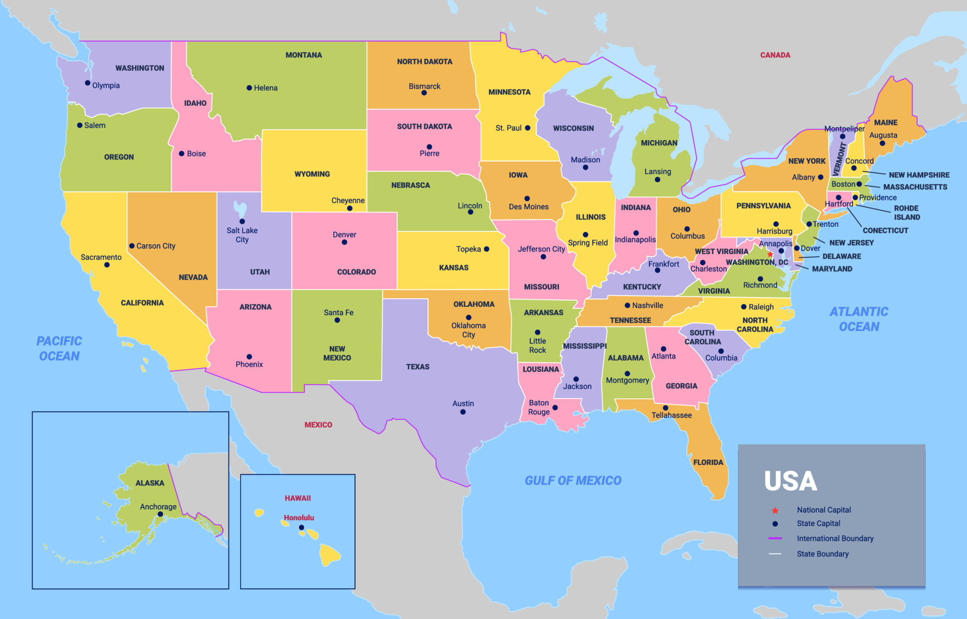
Mapping the Atlantic seaboard from Maine down to the coral shores of Florida reveals fourteen direct ocean-bordering states, alongside several tightly linked neighboring territories that share the region's cultural and economic ecosystem. When you look at a map of the United States, tracing this corridor from top to bottom cuts through immense historical milestones, varied climates, and dense metropolitan sprawls that define the eastern seaboard.
The primary answer to what states make up this coastal line consists of fourteen jurisdictions with direct shorelines touching the Atlantic Ocean. Moving sequentially from the northernmost boundary down to the southern tip, this geographic sequence provides a clear blueprint of the American eastern seaboard.
The Northern Anchor: New England States
New England comprises six states, five of which feature direct Atlantic coastlines. This region is characterized by rocky shores, historic maritime towns, and shifting seasonal weather patterns that range from heavy winter snows to mild coastal summers.
Maine
Maine sits at the absolute northeastern tip of the country. Its jagged coast features thousands of islands, rocky headlands, and deep inlets known as bays. Famous for commercial fishing, maritime heritage, and Acadia National Park, it serves as the northern starting point for the long coastal stretch down to the tropics.
New Hampshire
New Hampshire has a surprisingly short ocean coastline—roughly eighteen miles—sandwiched between Maine and Massachusetts. Despite its brief frontage on the Atlantic via Portsmouth and Hampton Beach, the state plays a vital role in New England's regional trade and maritime history.
Massachusetts
Massachusetts boasts a distinct, curved coastline shaped like a bent arm, featuring Cape Cod, Martha's Vineyard, and Nantucket. Boston anchors this coastal territory as a major economic and historical hub. The ocean shapes everything from the local seafood economy to the historic shipping ports dotted along the North and South Shores.
Rhode Island
Rhode Island is the smallest state in the country by area, yet it earns its nickname as the Ocean State through its extensive tidal inlets and Narragansett Bay. Hundreds of miles of sandy shores and historic Newport mansions define its marine-centric geography.
Connecticut
Connecticut borders Long Island Sound, a tidal estuary of the Atlantic Ocean. While it doesn't face the open ocean directly, its protected waters and major river mouths connect it deeply to the maritime trade network of the broader seaboard.
The Mid-Atlantic Core: Historical and Economic Powerhouses
Moving south past New England brings you to the Mid-Atlantic states. These territories drive massive portions of the national economy, feature major shipping channels, and hold some of the oldest colonial settlements in the country.
New York
New York features a dual coastline: one facing the Atlantic along the south shore of Long Island and the Hamptons, and another facing the tidal Hudson River estuary. New York City acts as the ultimate focal point for finance, culture, and global shipping along the seaboard.
New Jersey
New Jersey sits entirely within the Atlantic watershed, featuring more than a hundred miles of Atlantic coastline stretching from Sandy Hook down to Cape May. The state is bounded by the Hudson River and the Atlantic Ocean to the east and the Delaware River to the west. You can read more about its regional placement through the U.S. Census Bureau.
Pennsylvania
Pennsylvania is frequently debated because it lacks a direct ocean beach, yet it is traditionally grouped into regional East Coast discussions. The navigable Delaware River connects Philadelphia directly to the Atlantic Ocean, allowing major cargo ships to dock inland.
Delaware
Delaware features a compact coastline along the Delaware Bay and the Atlantic Ocean. Rehoboth Beach and Lewes anchor its beach culture, while its strategic location has made it a corporate and historical anchor point since the founding era.
Maryland
Maryland is deeply fractured by the Chesapeake Bay, the largest estuary in the United States. While its direct ocean exposure is limited to a small stretch at Ocean City, miles of tidal shorelines connect its communities directly to Atlantic shipping lanes.
The Southern Seaboard: Transition to Subtropical Climates
As the seaboard continues south, the landscape flattens into coastal plains, marshlands, and barrier islands, shifting into warmer climates and distinct cultural landscapes.
Virginia
Virginia's coastline is defined by the Chesapeake Bay and the Hampton Roads harbor, one of the world's largest natural deep-water harbors. Cities like Norfolk and Virginia Beach manage massive naval operations tied directly to the Atlantic.
North Carolina
North Carolina features the Outer Banks, a string of narrow barrier islands that buffer the mainland from fierce Atlantic storms. Cape Hatteras and Cape Lookout form treacherous shallow waters historically known as the Graveyard of the Atlantic.
South Carolina
South Carolina features historic lowcountry geography, characterized by tidal marshes, blackwater rivers, and the iconic sea islands. Charleston serves as its primary historic port city, facing the open Atlantic with a distinct architectural and cultural footprint.
Georgia
Georgia rounds out the lower seaboard with its own set of barrier islands, known as the Golden Isles, and a vital deep-water port in Savannah. While its coastline is shorter than neighbors like North Carolina or Florida, it maintains a critical economic gateway to the ocean.
Florida
Florida forms the southern anchor of the entire East Coast mapping project. Its Atlantic coast stretches from the historic shores of St. Augustine down through Miami and onward to the coral keys. The Gulf Stream current hugs this coastline, driving warm tropical weather patterns across the region. For broader geographic data on these states, consult the USGS.
Common Misconceptions About East Coast Borders
Geographic definitions often create confusion regarding which states officially qualify as part of the coast.
- Landlocked neighbors: States like Vermont, West Virginia, and Pennsylvania are often associated with eastern regional politics or history, but only Pennsylvania maintains a tidal shipping connection via the Delaware River.
- The Gulf vs. the Atlantic: Florida possesses two distinct coasts. Its western shore faces the Gulf of Mexico, while its eastern shore belongs strictly to the Atlantic Seaboard.
- Washington D.C. distinction: While the nation's capital sits along the tidal Potomac River connected to the Chesapeake Bay, it operates as a federal district rather than a sovereign state.
Frequently Asked Questions
How many states make up the official East Coast?
Fourteen states feature direct coastlines touching the Atlantic Ocean. When including regional neighbors with tidal or close economic ties, that number expands depending on the specific context of the study.
Does Pennsylvania count as an East Coast state?
Yes and no. Pennsylvania has no direct beach touching the open ocean, but the Delaware River provides a tidal route to the Atlantic, and the state participates directly in Mid-Atlantic regional planning.
What is the longest coastline on the East Coast?
Florida possesses the longest overall coastline in the region when combining both its Atlantic and Gulf exposures, though states like North Carolina feature massive barrier island chains stretching hundreds of miles.
Where does the East Coast begin and end?
Geographically, the seaboard runs from the Canadian border in Maine down to the southern tip of the Florida peninsula, bridging sub-arctic northern ecosystems with subtropical southern environments.



