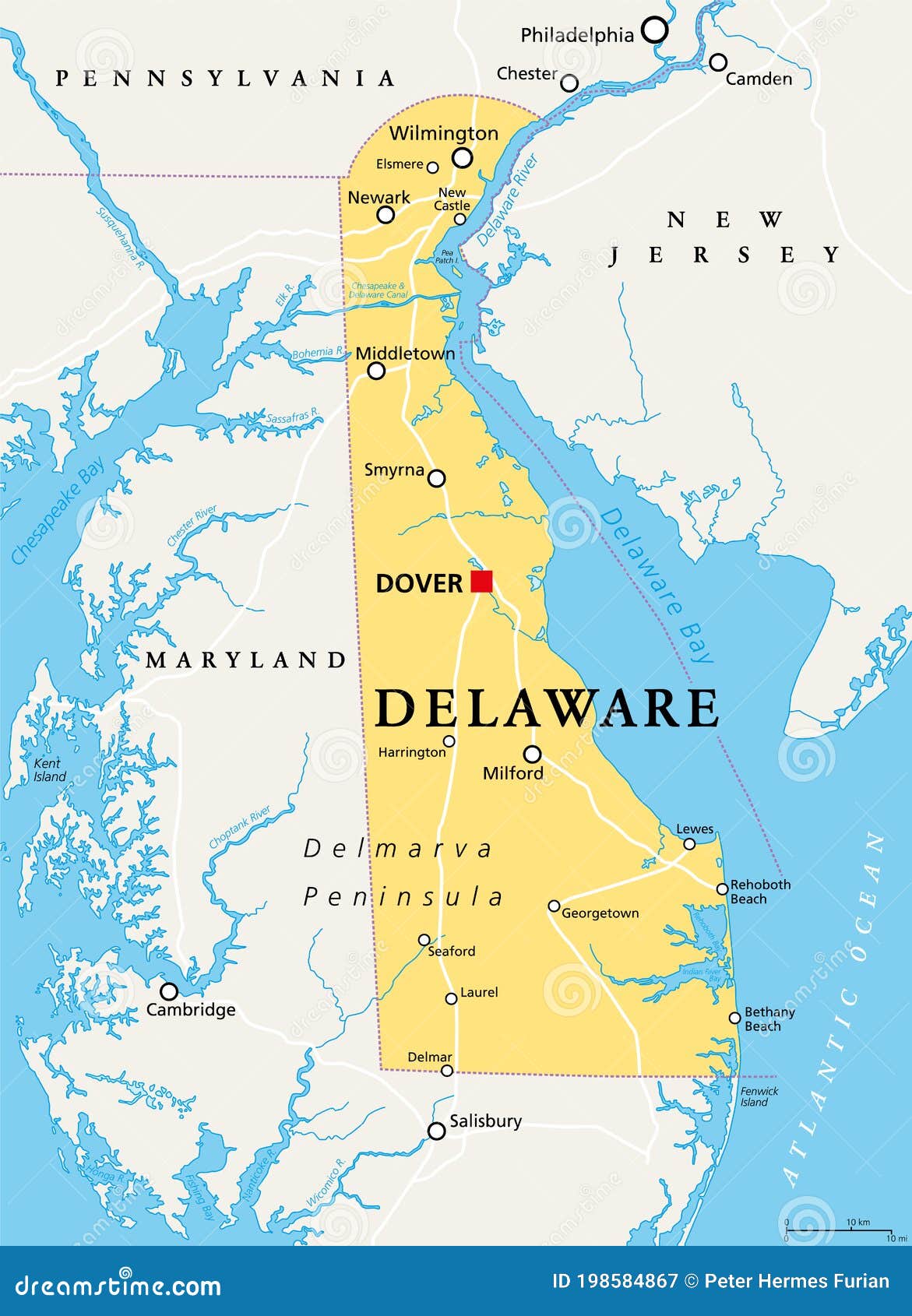
Geography shapes how a region develops, how its ecosystems function, and where its people live. When looking at Delaware, people often confuse the entire U.S. state with Delaware City, a historic waterfront municipality located in New Castle County. Both share a landscape defined by coastal plains, tidal wetlands, and low-lying terrain, but they scale differently across the Mid-Atlantic region.
Delaware sits on the northeastern portion of the Delmarva Peninsula, bordered by the Delaware River, Delaware Bay, the Atlantic Ocean, and Maryland. It holds the second-smallest land area of any U.S. state at roughly 1,982 square miles, yet features a high population density packed into distinct topographic zones. Understanding its physical layout requires looking beyond state lines to examine how elevation, waterways, and climate interact across its northern hills and southern flatlands.
Topographic Layout: From Piedmont Hills to Coastal Lowlands
The geography of Delaware transitions dramatically from north to south. While the state is famous for being flat, its northern tip actually dips into the rolling Piedmont plateau.
The Northern Piedmont Region
In northern New Castle County around Wilmington, the terrain features low, rolling hills formed of ancient metamorphic and igneous rock. This is the only part of the state with significant elevation changes, reaching a high point of roughly 448 feet near Ebright Azimuth. Streams here carve steep, rocky valleys before feeding into the Delaware River.
The Atlantic Coastal Plain
South of the Chesapeake and Delaware Canal, the landscape flattens entirely into the Atlantic Coastal Plain. This area accounts for the vast majority of the state's total land area.
- Low Elevation: The state features the lowest mean elevation in the United States, sitting at just 60 feet above sea level.
- Sandy Soils: Soils transition from rich clays in the north to sandy loams and deep sands toward the south, heavily influencing local agriculture.
- Flat Topography: Drainage is slow across these flatlands, which historically created vast expanses of wetlands and saturated soils.
Major Water Systems and Coastlines
Water defines the borders and internal geography of Delaware more than almost any other natural feature. The region acts as a massive drainage basin funneling water into major estuaries.
The Delaware River and Bay Estuary
The eastern boundary is shaped by the Delaware River, which widens into the Delaware Bay before meeting the Atlantic Ocean. Tides push far up the river, creating brackish environments where freshwater mixes with saltwater.
Wetlands and the Great Cypress Swamp
Poor drainage across the coastal plain gave rise to extensive wetland ecosystems, most notably the Great Cypress Swamp in the southern extreme near Selbyville.
- Salt marshes line the coastal bays, acting as critical nurseries for marine life and marine birds.
- Tidal creeks like the Murderkill and Mispillion flow eastward into the Delaware Bay, while a few western streams drain into the Chesapeake Bay watershed.
- The Chesapeake and Delaware Canal cuts a 14-mile commercial trench across the northern neck of the state, connecting the Delaware River directly to the Chesapeake Bay.
Climate Patterns and Regional Weather
Delaware experiences a temperate, humid climate influenced heavily by the Atlantic Ocean and the Delaware Bay. Because the landmass is narrow, maritime air masses moderate extreme temperatures compared to inland states at the same latitude.
Seasonal Variations
Winters are generally mild to moderate, though coastal nor'easters can drop heavy wet snow and cause tidal flooding. Summers bring high humidity with frequent afternoon sea breezes that cool immediate coastal strips. Precipitation is distributed evenly throughout the year, averaging around 43 to 45 inches annually, supporting dense pine and hardwood forests.
Microclimate Differences
Even within a small geographic footprint, distinct microclimates exist:
- Northern New Castle County experiences slightly cooler winter temperatures and higher snowfall totals due to elevation and distance from the open ocean.
- Southern Sussex County enjoys milder winter lows because it is surrounded by warmer coastal waters on multiple sides.
Comparing Delaware State and Delaware City Geography
Confusion often arises between the broader state geography and Delaware City, a specific municipality situated along the northern waterfront.
| Geographic Feature | State of Delaware | Delaware City (Municipality) |
|---|---|---|
| Total Area | ~1,982 square miles | ~5 square kilometers (mostly land) |
| Primary Drainage | Delaware Bay & Chesapeake Bay watersheds | Delaware River & C&D Canal intersection |
| Topographic Profile | Piedmont rolling hills to flat coastal plains | Low-lying coastal flatlands adjacent to tidal wetlands |
| Strategic Location | Delmarva Peninsula gateway to the Northeast | Historic transshipment point opposite Pea Patch Island |
Frequently Asked Questions
What is the highest point in Delaware?
The highest natural point is Ebright Azimuth, located in northern New Castle County near the Pennsylvania border. It sits at an elevation of 448.28 feet above sea level, making it the lowest state high point in the nation.
Why is Delaware's western border a straight line?
The border with Maryland features the famous Transpeninsular Line and the Twelve-Mile Circle, surveyed by Charles Mason and Jeremiah Dixon between 1763 and 1768. This survey resolved decades of bitter land disputes between the Penn family of Pennsylvania and the Calvert family of Maryland.
Does Delaware have natural lakes?
Almost all lakes and ponds in the state are artificial impoundments created by damming sluggish streams for early gristmills and sawmills. Tracers of natural glacial lakes found in northern states are absent here because glacial ice sheets stopped just short of Delaware's current borders.
How does sea level rise impact Delaware's geography?
Because Delaware has the lowest mean elevation in the country, its extensive salt marshes, sandy barrier islands, and low-lying coastal communities are particularly vulnerable to rising sea levels and intense storm surges driven by Atlantic hurricanes.



