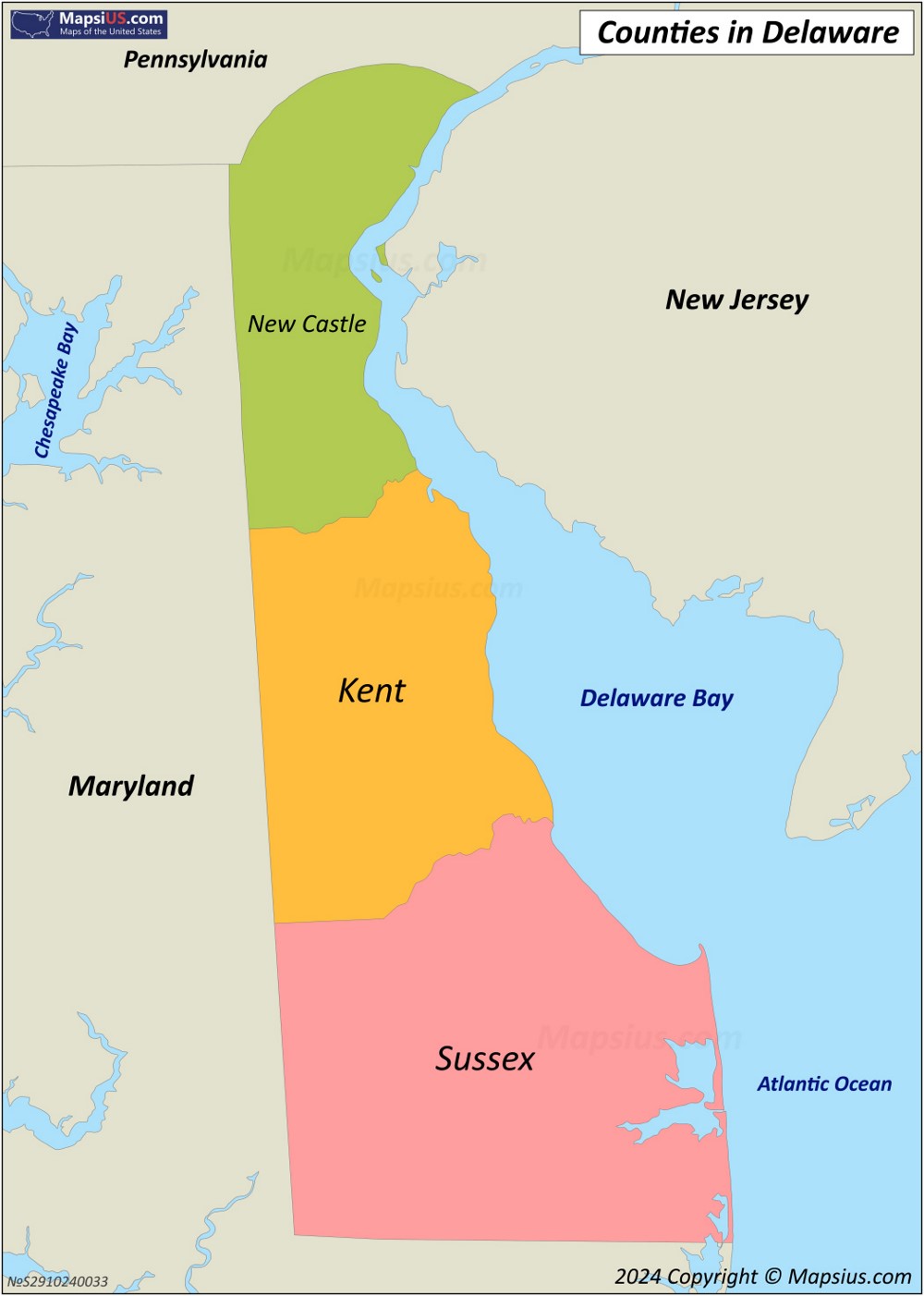
Navigating Delaware means traversing one of the most compact states in the nation. Measuring roughly 96 miles long from north to south and between 9 and 35 miles wide east to west, the First State allows drivers to cross its entire length in under two hours under normal conditions. Yet, despite its small size, regional travel varies dramatically based on whether you are navigating the dense urban traffic of New Castle County or the rural coastal highways of Sussex County.
Understanding Delaware distances requires looking past simple mileage numbers. Traffic bottlenecks along the Interstate 95 corridor, seasonal beach congestion down Route 1, and the physical barrier of the Chesapeake and Delaware Canal all impact travel times. Whether you are commuting from Wilmington to Dover or planning a weekend trip to Rehoboth Beach, knowing the layout of this compact corridor saves time and frustration.
The Geography of Delaware: A Compact Corridor
Delaware sits within the Mid-Atlantic region, bordered by Maryland, Pennsylvania, New Jersey, and the Atlantic Ocean. Its unique shape is the result of colonial land grants and historical disputes, notably the Twelve-Mile Circle surrounding New Castle.
The state divides naturally into three distinct geographic regions:
- Northern New Castle County: Highly urbanized and suburban, anchored by Wilmington, Newark, and the I-95 industrial corridor. This area features heavy commuter traffic, complex interchanges, and dense population clusters.
- Central Kent County: Dominated by state government in Dover, agricultural fields, and air force operations. Travel here opens up significantly compared to the north.
- Southern Sussex County: Known for its beach resorts, flat coastal plains, and expanding retirement communities. Seasonal tourism heavily dictates traffic flow here.
Because Interstate 95 cuts diagonally through the northern tip of the state, many drivers pass through Delaware without realizing its full north-south span. The distance from the Pennsylvania state line down to Fenwick Island at the Maryland border is approximately 98 miles via Route 1 and US-13.
Key Mileage and Drive Times Between Major Hubs
Planning a trip within the First State involves short physical distances that can sometimes yield surprising drive times during peak hours. Here is a breakdown of standard routes:
Wilmington to Dover
- Distance: Approximately 45 miles south via US-13 or Route 1.
- Typical Drive Time: 45 to 60 minutes.
- Travel Notes: This corridor links the commercial hub of the north with the state capital. Route 1 features toll sections that speed up travel, while US-13 offers a slower, commercial strip alternative with numerous traffic lights.
Wilmington to Rehoboth Beach
- Distance: Approximately 85 miles south.
- Typical Drive Time: 1 hour 30 minutes to 2 hours.
- Travel Notes: Summer weekends transform this route into a high-congestion zone. Drivers head south down Route 1, where bottleneck areas near the Dover Air Force Base and the Indian River Inlet Bridge can cause significant delays.
Dover to Lewes
- Distance: Approximately 40 miles southeast.
- Typical Drive Time: 40 to 50 minutes.
- Travel Notes: A straightforward drive across central and southern agricultural lands, primarily using Route 1 South. Traffic remains generally steady except during peak beach turnover days on Fridays and Sundays.
Newark to Wilmington
- Distance: Approximately 14 miles east.
- Typical Drive Time: 20 to 30 minutes.
- Travel Notes: Navigating home to the University of Delaware and the state's largest city requires dealing with I-95 rush hour traffic, particularly around the Christiana Mall interchange.
Navigating the Toll Network and Alternate Routes
Delaware relies heavily on toll revenue to maintain its main highways, particularly Interstate 95 and Delaware Route 1. Understanding where these tolls are located helps you manage travel costs and choose efficient alternates.
The Delaware Department of Transportation operates electronic tolling systems that accept E-ZPass or Toll-By-Plate invoicing. On I-95 near Newark, tolls apply to all through-traffic. On Route 1, tolls increase during summer weekends to manage beach traffic volume.
If you want to avoid tolls or bypass construction backups, consider these strategies:
- The US-13 Alternative: Running parallel to Route 1, US-13 is a toll-free four-lane highway with frequent traffic lights and local businesses. It adds time to long-distance trips but provides a reliable backup when Route 1 accidents occur.
- Local Backroads: In Sussex County, secondary routes like Route 9 and Route 404 offer lateral east-west connections across the peninsula, linking rural towns without hitting major highway jams.
Seasonal Traffic Shifts and Congestion Points
The biggest variable in Delaware travel time is seasonality. Between Memorial Day and Labor Day, millions of visitors travel down the Route 1 corridor toward Rehoboth Beach, Dewey Beach, Bethany Beach, and Fenwick Island.
The Beach Traffic Phenomenon
On Friday afternoons and Sunday evenings, southbound and northbound Route 1 respectively experience severe slowdowns. Traffic engineers utilize lane-control signals and temporary traffic pattern adjustments to manage the surge, but delays remain common.
Commuter Bottlenecks in the North
In New Castle County, the Christiana Mall area and the I-95/State Route 1 interchange handle massive volumes of local and interstate commuters daily. Accidents in this zone ripple across the entire northern Delaware network within minutes. Checking real-time updates via the Delaware Department of Transportation before departure prevents major delays.
Common Navigation Mistakes to Avoid
Drivers new to Delaware often make a few predictable errors that turn short trips into frustrating ordeals:
- Underestimating beach traffic on overcast days: Many assume bad weather keeps tourists off the beach roads, but rainy weekends often prompt visitors to head inland for shopping outlets, clogging Route 1 just as heavily.
- Ignoring E-ZPass lane restrictions: Approaching toll plazas without an active transponder or straying into dedicated E-ZPass lanes by mistake leads to administrative fees via Toll-By-Plate billing.
- Relying solely on GPS during peak hours: Standard routing apps sometimes direct drivers onto rural shortcuts that quickly become gridlocked when thousands of other drivers attempt the exact same detour. Staying on major highways with active incident monitoring is often safer.
Frequently Asked Questions
How long does it take to drive across Delaware?
Driving from the northern border with Pennsylvania down to the southern border at Fenwick Island takes roughly one hour and forty-five minutes under normal traffic conditions, covering a distance of about 98 miles.
Do I need E-ZPass to drive in Delaware?
You don't need an E-ZPass transponder to use Delaware toll roads, but it offers a discount over the Toll-By-Plate system, which photographs your license plate and mails an invoice to your registered address.
What is the main highway running north-south through Delaware?
Interstate 95 handles north-south traffic through the northern tip of the state, while Delaware Route 1 and US-13 serve as the primary north-south arteries running down the entire length of the state toward the coastal resorts.
Why is Delaware traffic so heavy in the summer?
Sussex County features popular Atlantic beach destinations that attract visitors from Philadelphia, Baltimore, Washington D.C., and New York, multiplying the local population on weekends.



