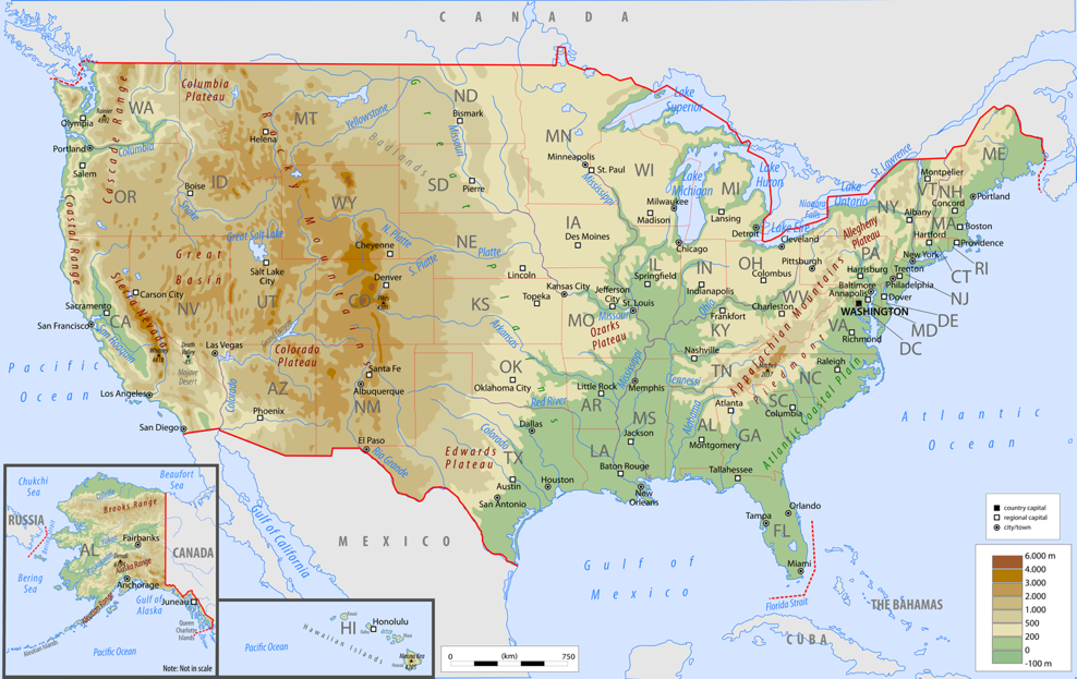
Boston sits firmly in the northeastern corner of the United States, serving as both the capital and the largest city of Massachusetts. Positioned along the Atlantic coastline on Massachusetts Bay, the city anchors the six-state New England region as its primary cultural, economic, and historic hub. If you're looking for its exact placement on a map, it's about 215 miles northeast of New York City and roughly 400 miles south of Montreal, Canada.
Understanding where Boston fits geographically requires looking at both its immediate coastal setup and its role as the historic gateway to the American Northeast. Let's break down its exact location, how it became the region's central crossroads, and what you need to know if you're planning a visit or studying its geography.
Geographic Placement and Boundaries
The city proper covers a relatively compact area of roughly 48 square miles, a surprising amount of which is actually water or reclaimed land. It sits where the Charles River empties into Boston Harbor.
- North and East: Bounded by Boston Harbor and the open Atlantic Ocean, opening up maritime routes used since the 1600s.
- West and North Across the River: Bordered by Cambridge (home to Harvard University and MIT) and Somerville.
- South and Southwest: Connected to mainland Massachusetts through tight urban corridors like Roxbury and Dorchester, extending out toward the broader interstate network.
The modern layout disguises its original geography. When Puritan settlers arrived in 1630, the settlement was a tiny, hilly peninsula called Shawmut, connected to the mainland by a single narrow strip of land. Over the centuries, civil engineers filled in surrounding coves and tidal flats, drastically expanding the landmass to accommodate a growing metropolis.
Why Boston Became the Crossroads of New England
Geography gave Boston an early advantage, turning it into the natural focal point for travel and trade across the entire northeastern seaboard.
A Natural Deep-Water Harbor
Before railways or interstate highways existed, coastal shipping dictated economic power. Boston Harbor offered a sheltered, deep-water basin protected from the open ocean by a series of islands and peninsulas. This allowed merchant ships to dock safely, turning the city into a dominant colonial trading post.
The Hub-and-Spoke Transportation Network
As the colonies grew, roads radiated outward from Boston like spokes on a wheel. Today, this historic pattern is mirrored in the modern highway system. Major arteries converge on the city:
- Interstate 95: Runs up and down the Atlantic seaboard, connecting New England to New York and the Mid-Atlantic.
- Interstate 90 (The Mass Pike): Cuts horizontally across Massachusetts, linking Boston directly to the New York State Border and the Midwest.
- Interstate 93: Heads straight north toward New Hampshire and Maine, serving as a vital commuter and freight corridor.
These roadways follow paths originally cleared by Indigenous populations and early colonial farmers, cementing Boston's status as the literal crossroads of the region.
Navigating the City Today
If you're visiting or moving to the area, navigating Boston requires a different mindset than grid-based cities like New York or Chicago. Streets often follow winding 17th-century cow paths rather than a strict mathematical layout.
The Massachusetts Bay Transportation Authority MBTA, locally known as "the T," operates the oldest subway system in the United States. It connects downtown neighborhoods to surrounding suburbs, making car-free travel feasible for tourists and locals alike. For detailed trip planning and regional transit maps, you can check the Mass.gov official portal.
Common Misconceptions About Boston's Location
Travelers often confuse Boston's hyper-local boundaries with its massive metropolitan footprint.
- City vs. Metro: The city proper houses around 650,000 residents, but Greater Boston encompasses over 4.5 million people. Towns like Brookline, Cambridge, and Quincy feel like distinct neighborhoods of Boston even though they maintain separate municipal governments.
- Proximity to Other States: People underestimate how close Boston is to neighboring states. You can drive to Rhode Island or New Hampshire in under an hour, and Connecticut is roughly a 90-minute drive southwest.
Frequently Asked Questions
What US state is Boston in?
Boston is located in the Commonwealth of Massachusetts, serving as its capital city and economic engine.
Is Boston considered part of New England?
Yes. Boston is widely regarded as the cultural and historical capital of New England, which includes the six states of Massachusetts, Rhode Island, Connecticut, New Hampshire, Vermont, and Maine.
How far is Boston from New York City?
By car or train (via Amtrak's Acela or Northeast Regional lines), Boston is roughly 215 miles northeast of New York City, usually translating to a 3.5 to 4-hour trip depending on traffic or rail choice.
Why is Boston called a historic crossroads?
Its natural harbor and central geographic position made it the primary entry point for European settlers, trade goods, and political movements that shaped the northeastern United States from the colonial era through the American Revolution.



